
Aviation Forecasting - a Forecaster's Perspective
Wanting to know what the weather is going to do today is a very British preoccupation. Although so many share this interest, a quick glance at a list of potential forecast customers reveals that everyone seems to need subtly different information. For example;
- gardeners worry about temperature and late frosts
- sailors need information about wind and sea state
- drivers want to know about icy patches on a freezing winter night
- people living on flood plains need heavy rain warnings
This is one reason why the role of Operational Meteorologist (or ‘Weather Forecaster’ as my old job was called) is such a fascinating one; not least when the forecast is for flying. Pilot’s needs are very specific and often very different to those of other groups, like the ones mentioned above.
What does a pilot want to know?
You don’t have to do much flying training to realise that being able to see the ground and where you are going are important for a successful flight. Indeed, these are mandatory requirements for those with less experience, operating under Visual Flying Rules (VFR). For that reason the height, type, thickness and overall coverage of any CLOUD is vital information and far more important than a ground-based customer’s concern over whether cloud-breaks will permit the sun to shine today.
‘Never start what you cannot stop’ is an appropriate rule-of-thumb in many situations. But, if not being able to stop is caused by your inability to see the runway you are trying to land on at the end of your flight, this rule assumes extra significance. The impact of heavy rain or snow or fog on the VISIBILITY (the distance you can see clearly) are of great import to the flyer and far more relevant than knowing whether it will be wet as you walk out of the hangar. Pilots are also specifically interested in how far they can see along the runway on take-off (Runway Visual Range). This may be different to the overall visibility in the area.
It’s all very well being able to see your way home, but if you are finding it hard to travel in a straight line, then things may still end badly. In the context of flying, this problem can be encountered when the WIND is very strong, particularly when it is blowing across the line you are hoping to steer. Landing a plane in a crosswind, especially when it is turbulent, gusting and changing its direction by a few degrees every so often, is one of the most difficult skills to acquire in a light aircraft and one of the most dangerous moments in any flight. Accurate wind forecasts are therefore essential and may well limit operations for inexperienced pilots.
Flying experience
Of course, there is yet another variable which must be considered alongside the forecasting of cloud, visibility, wind, or indeed any other element you care to consider (of which more later). That is the experience and skill of the pilots themselves. Very inexperienced trainees will need a guarantee of excellent weather before they will be cleared to fly, whereas fully qualified, highly experienced pilots will be able to operate safely in poorer conditions. The key is to know and understand your own limitations; something which applies just as much to the forecaster. There is no point in telling a pilot what he or she wants to hear, that the weather is going to remain cloudless, calm and with perfect visibility, if you have to cross your fingers behind your back as you say so!
When is a cloud really fog?
There are many more constituents of a flying forecast that carry varying degrees of importance as a pilot develops their skills. Of these, one is the issue of height of cloud above the ground. It sounds so simple, until you reflect that, whilst the ground at any one location is at a fixed height, the same is not necessarily true of all the ground along a proposed route. This means that, whereas cloud height at a specific location is both reported and forecast with reference to the ground at that location, it is given in terms of its height above sea level when a large area or a route to follow is concerned.
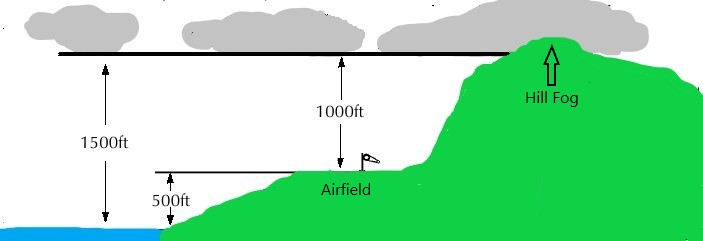
Image 1: Schematic illustrating that cloud at 1500ft above sea level is at a height of 1000ft above ground at an airfield but obscures the top of nearby hills which rise to more than 1500ft above sea level.
The only way of knowing whether or not the hill you hope to fly over is clear or covered in hill fog is by comparing its charted height above sea level with the height of the cloud itself above sea level, rather than the height of the cloud above ground at an airfield. Ignoring this can unfortunately be disastrous.
Other matters of interest to a flyer would include subjects dear to our motorist’s heart, such as ice and snow on runways and taxiways and indeed on the aeroplane itself. Later, as experience leads to authorisation to fly under Instrument Flying Rules (IFR), the issue of icing in cloud raises its head. This can occur when flying through a cloud which consists of super-cooled droplets. If the airframe is itself also sub-zero, rime ice can deposit onto it, materially changing the flying characteristics of the aeroplane, and not for the better!
The pilots’ mantra “ASSUME MAKES AN ASS OUT OF U AND ME” always struck me as an excellent reminder that you should never take anything for granted, least of all, the Great British Weather!
On Saturday 10 April 2021, the Royal Meteorological Society in collaboration with the General Aviation Safety Council (GASCo) is hosting a webinar focussed on improving safety for all General Aviation pilots at the Private Pilots Licence level, through an understanding of the weather. Find out more about the ‘Weather for Private Pilot Licence Holders’ virtual event here.
The author spent several years forecasting for pilots ranging from novices to expert flyers operating in a wide variety of aircraft in different geographical locations. No two days were ever completely the same!

")

