
Dry Aprils
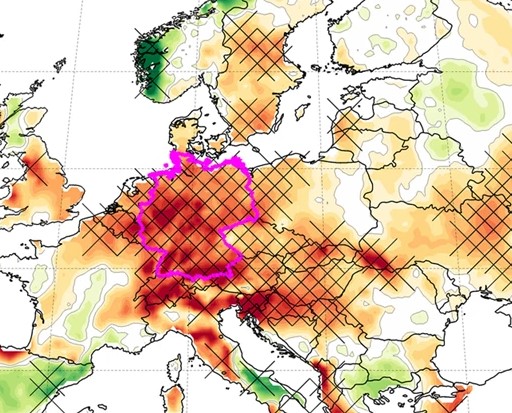
Main image: April precipitation anomalies for the period 2007–2020. Source: Ionita et al (2020)
We recently posted about ‘April Showers’, but is the cliché true? At the time of writing (April 2021), recent British weather has been heavily influenced by areas of high pressure (anticyclones). This means that some parts, including much of central and southern England, have seen dry conditions, with fronts and rain stalling over western areas, especially in Ireland and Scotland.
This prompted us to take a look at a paper by Dr Monica Ionita (Alfred Wegener Institute Helmholtz Center for Polar and Marine Research) and colleagues, which draws attention to how much drier European Aprils have been since 2007.
Over the last 14 years, Central Europe has seen drought conditions almost every April. Rainfall has been around 50% of average over wide areas. In Germany, the April temperature from 2007-2020 was almost 3˚C warmer than that in the period from 1880-1910; April 2018 was the warmest on record, whilst April 2020 was the sunniest. River flow was also reduced with new low-flow records set on the Elbe. These unusual conditions were found in many European countries, with Germany, Poland, Czech Republic, Hungary and Ukraine particularly affected. But the UK, France, Belgium, Netherlands, Denmark and the Baltic states all saw drier than average weather overall. Before 2007, dry and warm weather did indeed occur in some April months, but these events tended to be occasional rather than running over successive years.
Dry conditions in the spring were also found to lead to a worsening of summer droughts over Europe since, at the very time when moisture in the ground would be expected to be topped up by April rain, it was becoming drier. Typically, over the last 140 years, droughts in Europe have been features of late summer or early autumn. However, since 2007, these have been exacerbated by a dry spring as well.
In recent years, notably warm and dry April conditions were found to be heavily influenced by the persistence of a blocking anticyclone over the North Sea and Central Europe. These blocks interrupt the normal westerly airflow which usually brings with it regular depressions and rain to the region. Instead, the normal run of storms is pushed further north. Such a situation is one in which the North Atlantic Oscillation Index is often negative. It is thought that there is also a link to a reduction in the temperature difference between the high latitudes and the Tropics, which is associated with recent Arctic warming. However, a clear relationship to our understanding of the relative importance of human-produced warming is not yet available. Nevertheless, it is another area of study which needs to be considered in the battle to prevent future climate change.
Source: Ionita, M., Nagavciuc, V., Kumar, R. et al. On the curious case of the recent decade, mid-spring precipitation deficit in central Europe. npj Clim Atmos Sci 3, 49 (2020). https://doi.org/10.1038/s41612-020-00153-8


