
El Niño
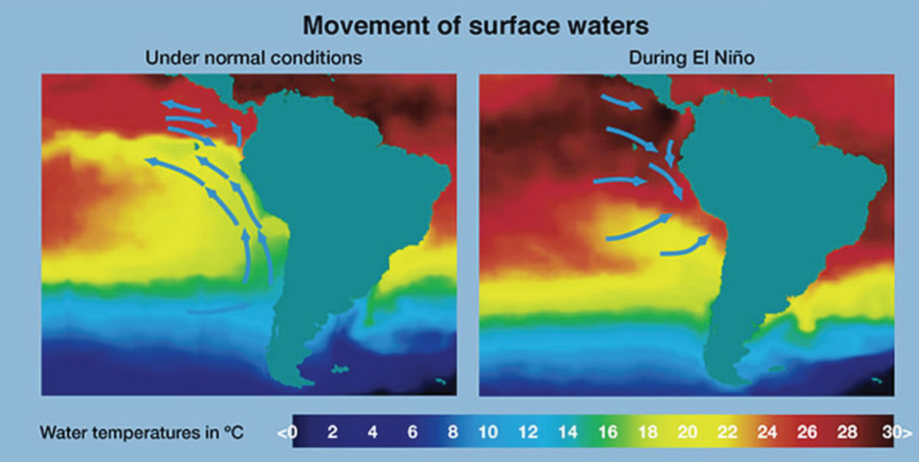
The name El Niño, Spanish for ‘child or ‘the Christ child’, was first used by fishermen along the coasts of Ecuador and Peru to refer to a warm ocean current that typically appears around Christmastime and lasts for several months. Fish are less abundant during these warm intervals, so fishermen often took a break to repair their equipment and spend time with their families. However, over the years, the term El Niño Southern Oscillation (ENSO) has come to be reserved for the more exceptionally strong warm intervals that not only disrupt the everyday lives of the fishermen but also disrupt the climate conditions around the world.
The temperature of the sea surface in the eastern tropical Pacific is typically around 27°C, which is quite balmy compared to UK waters but relatively cold for the tropics. As a result, cooler waters from deeper in the ocean rise up in the eastern Pacific, bringing nutrients that feed a thriving ecosystem. However, when the trade winds weaken, the higher sea surface temperatures in the western Pacific move eastwards, bringing atmospheric convection with them, further weakening the trade winds. This weakening also reduces the upwelling of cold water in the ocean, further enhancing the higher sea surface temperatures in the east. This warming is what we call an El Niño event.
During the past 50 years, nine significant El Niño events have affected the South American coast. Most of them raised water temperatures along the coast and in a belt stretching 5,000 miles across the equatorial Pacific. The weaker events raised sea temperatures by only one degree and impacted the local climate. But during a significant warming event, like the El Niño of 1982-83, the impact was not only upon the local weather and marine life but also on global climatic conditions.
During an El Niño event, the warmer oceans supply vast amounts of energy, which means strong convection and heavy rainfall in South America, the Galapagos Islands and California. At the same time, rainfall is reduced over Indonesia, Malaysia, and northern Australia and drier than normal conditions over southeastern Africa and northern Brazil during the northern winter season. El Niño affects atmospheric circulation features, such as the jetstreams in the subtropics and in the temperate latitudes of the winter hemisphere, which can result in persistent blocking patterns leading to significant temperature and precipitation anomalies. Also, during the northern winter season, mid-latitude low-pressure systems tend to be more vigorous than normal in the eastern North Pacific. These systems pump unseasonably warm air into western Canada and Alaska. Storms also tend to be more vigorous in the Gulf of Mexico and along the southeast coast of the United States, resulting in wetter winters. During the northern summer season, Indian monsoon rainfall tends to be less than normal, especially in northwest India. Wetter than normal conditions are observed along the west coast of tropical South America, at subtropical latitudes of North America around the Gulf Coast and from southern Brazil to central Argentina. It also creates strong wind shear, making it harder for storms to develop into hurricanes in the Atlantic.
Extreme El Niño events are predicted to double over the next century. Until recently, it was thought that this phenomenon would be relatively unaffected by climate change, but a new study published in Nature Climate Change says we’re now likely to see an extreme El Niño every decade. ‘This is a highly unexpected consequence of global warming,’ says Professor Mat Collins of the University of Exeter, one of the authors. ‘Tropical rainfall conditions such as those experienced in extreme El Niños can dramatically influence the world through flooding rains, bushfires and drought. The impact on people, particularly fishermen in developing nations or farmers, is substantial. It is essentially an irreversible climate change phenomenon’ Professor Collins adds. By studying separate simulations of future climate, the international team consistently found pronounced warming in the eastern Pacific over the next century. Those perpetually warmer waters will mean that a relatively modest increase in temperatures from El Niño could affect global rainfall dramatically.
With an El Niño event predicted during the second half of 2014 and into 2015, one thing is certain - we will be hearing more about this phenomenon.
Find out more about ENSO in this Royal Meteorological Society's podcast about El Niño and La Niña with Professor Adam Scaife.


