
Long range forecasting of an exceptional summer - by James Warner
It’s not often we can use words such as dry, hot, and sunny, to describe a UK summer. Although we commonly experience a hot spell of weather most years, this summer has been particularly unusual in the persistence of dry, sunny weather, which extends back to late May. What makes it more pronounced is the stark contrast to spring, which saw well below average temperatures in March and above average rainfall into April. Recent summer weather has led to a range of stresses on the environment, such as wildfires in parts of England, as well as on us in terms of heat related health complications. In the past few days alone, extreme temperatures have occurred over Portugal and Spain, with temperatures in the upper 40’s. If we can forecast such weather patterns well in advance, then we can be better prepared for such extremes.
Most of the dry, sunny weather this summer stems from the persistence of high pressure over northern Europe, which has prevented low pressure systems in the Atlantic from influencing the UK and bringing in cooler, wetter air. Many have likened the current summer to the hot summer of 1976, which saw remarkable heatwave and drought. The exact location of the high pressure is important in determining conditions over the UK; wind travels clockwise around high pressure in the northern hemisphere, so if high pressure is to the east of us, it allows hot, warm air to push up from southern Europe. There has been a few brief interludes where the Atlantic has had some influence and the high pressure has weakened, but there has been a tendency for it to restore time and time again.
Higher than average pressure over the UK has been forecast well over much of the summer, both in medium range weather prediction (1-2 weeks) and long range prediction (2+ weeks), from a range of weather modelling centres. The Met Office contingency planners summary has forecast above average temperatures and below average precipitation for the past few months, with this pattern set to continue into late summer/early autumn. Below is a forecast from the Met Office for the next few months (August to October average), showing a prediction for below average rainfall and above average temperatures. The model is run many times (each run is called an ensemble) with slightly different starting conditions, to obtain a more robust prediction and to take into account uncertainties in the initialisation of the model; the blue crosses represent the individual model runs.
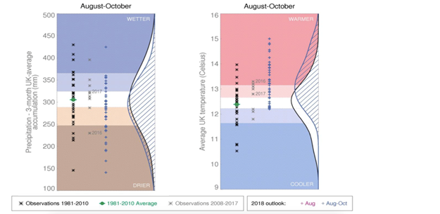
From https://www.metoffice.gov.uk/binaries/content/assets/mohippo/pdf/public-sector/forecast-temp-aso-v1.pdf and https://www.metoffice.gov.uk/binaries/content/assets/mohippo/pdf/public-sector/forecast-precip-aso-v1.pdf, amended
To forecast on such long timescales, forecasters need to look at weather patterns in much more remote locations, such as in the Atlantic, or even in the tropics. Weather occurring many thousands of miles can affect weather locally – the atmosphere and ocean is all connected. One remote region that can affect weather here is in the tropical Pacific, through variation in sea surface temperatures. This is called the El Niño Southern Oscillation (ENSO), which leads to large variations in tropical rainfall. This can affect the jet stream in the upper atmosphere nearer to us, particularly in winter. The ENSO state is currently in a neutral phase, so wouldn’t be expected to affect weather around the UK.
A region more local to us that has been linked to the persistence of high pressure over the UK is northern North Atlantic sea surface temperatures, as shown in the image below (from https://www.tropicaltidbits.com/analysis/ocean/cdas-sflux_ssta_atl_1.png)
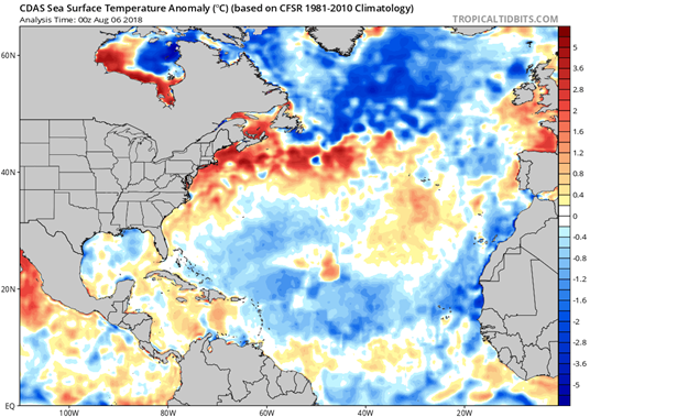
Here, we can see anomalously cold water stretching from Iceland to the north east coast of Canada. This pattern increases the probability of high pressure over northern Europe, and given that sea surface temperature anomalies persistent on weekly to monthly timescales, it can be used as a prediction tool for summer weather over the UK.
More local effects dictate how warm the air will actually be, which range from cloud cover to wind speed. However, recent weather has led to some more persistant changes that will affect how warm it will be in the coming weeks. For example, this unusually warm summer has warmed sea surface temperatures immediately surrounding the UK, which will enhance any warm spell. Another positive feedback is that the ground is very dry – this leads to higher daytime maximum temperatures as the ground warms more quickly, and therefore heats the air more. Some recent soil temperatures reached 50C on sunny days with low wind speed, according to Reading University’s meteorological observatory (http://www.met.reading.ac.uk/weatherdata/).
Recent heat extremes in Europe are predominantly due to the unusual persistence in high pressure over northern Europe. This can be linked back to more remote locations such as cold sea surface temperatures in parts of the North Atlantic, which increases the probability of high pressure. Daytime extremes in temperature are further enhanced with local feedbacks such as soil moisture and sea temperatures immediately around the UK. Met Office projections suggest a similar pattern to persistent into late August and early Autumn. Fortunately, as a result of average rainfall during winter and a wet spring, water reservoir levels are normal, but consider investing in a water butt – every rain shower counts!

James Warner - NERC GW4+ PhD Student University of Exeter


