
Coastal Flood Forecasting factfile
Flood forecasting – a coastal perspective
Hello, I’m Deb and I’m a Flood Forecaster at the Environment Agency. Following on from Jo and Alan’s blog on river flood forecasting, this blog will provide an insight into coastal flood forecasting and how it fits into the broader picture of informing and warning people before, during and after a flood incident. We will also cover some of the technical background to flood forecasting that allows us to deliver this service.
Early warning of flooding enables people, businesses and organisations to take action to reduce the impacts and stay safe. Flood forecasting is an important part of this warning service and in England covers river, coastal, groundwater and surface water flooding sources. We provide advance information on the likelihood of flooding, the scale of the potential flooding as well as when and where it may occur.
The most recent UK Climate Projections confirm that we can expect increases to extreme coastal water levels as a result of the increase in mean sea level, and that there is potential for changes in the severity of future storm surge events. Accurate flood forecasting helps the Environment Agency, our partners and the public make effective decisions early to save lives and livelihoods. We share and use flood forecast information to warn of extreme hazards. This means that tidal barriers, gates, defences, pumps or property protections can be put in place, and those at risk can evacuate if needed.
What makes up a coastal flood forecast?
We provide a 5 day coastal forecast along our coastline. This forecast is created and delivered through a partnership across several organisations (see Figure 1).
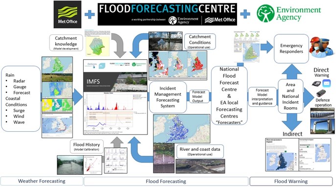
The National Oceanography Centre calculates astronomical tidal data for the year ahead. The astronomic forecast converts the gravitational action of the Sun and the Moon, in combination with bathymetry (seabed shape) to create a forecast water level at a specific location and time. Tides result from centrifugal and gravitational forces causing a bulge of water on either side of Earth. High tide occurs as the rotating Earth passes under each bulge, with roughly two tides per day, one smaller than the other.
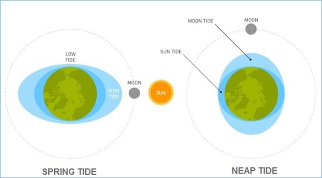
Tides vary throughout the month depending on the location of the Sun and the Moon in relation to the Earth (see Figure 2). Spring Tides occur twice a month just after the full and new Moons when the Sun and Moon are in alignment, creating a stronger gravitational force and therefore higher tides. Neap Tides occur at quarter Moon when the Sun and Moon are at 90 degrees to each other, the bulge of the ocean caused by the Sun’s gravity partially cancels out the bulge caused by the Moon’s gravity.
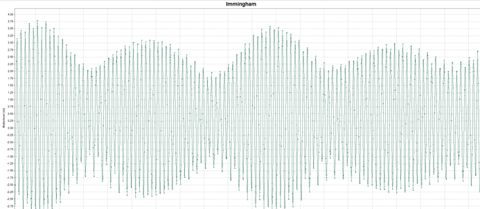
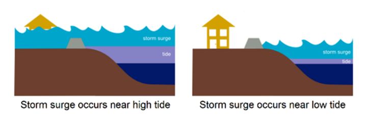
The astronomical data is one component of the coastal forecast that helps us to understand periods of potential risk (see Figure 3). This information is combined with the tidal surge forecast from the Met Office NEMO (Nucleus for European Modelling of the Ocean) model, which predicts the effect of ‘the weather’ on the sea’s water level. The surge is generated by low pressure and winds acting on the top of the water. The additional water level can be very significant and forecasting this variable is key to an accurate total water-level forecast. A large positive surge does not always generate flooding impacts, as it depends on the astronomical tide level as well as the local geography, which affects how coastal conditions affect risk (see Figure 4).
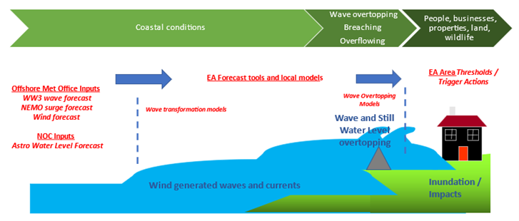
Forecast wind and wave data is provided by the Met Office from the Wave Watch III model. This data is used in ‘local’ forecast models to translate offshore wind and wave conditions into the nearshore so that forecasters can understand how this wave action combined with water level may overtop defences and cause flooding. This data is also used to identify conditions which have historically caused flooding impacts to understand the risk to communities for the next 5 days
Surge, wind and wave forecast data is available from MET Office models four times a day. This raw forecast data is pulled into our Incident Management Forecasting System (IMFS) as inputs to local coastal models. These local models have been developed to forecast for community-scale risk flood warning areas using local bathymetry, nearshore processes, beach and defence type, and historic impact information (see Figure 5). Different components of the coastal forecast play stronger roles on different parts of the coast, and forecasters need to interpret local coastal dynamics to decide how it will affect the communities on their coastline.
Risk on the east coast is driven by water level, where surges are generally larger and have more obvious 'peaks' than south coast events and are more easily 'followed' down the coast. The east coast has a complex bathymetry with a dynamic coastline that is eroding and accreting, and the shape of the coastline very much affects the severity of the impacts. In the Wash and the Thames estuary it is difficult to model and forecast the local complex interactions between the astronomical tide, surge and waves in shallow water areas. Northeasterly waves have the longest fetch and typically the longest wave period, impacting unsheltered stretches of the east coast.
The west coast risk is dominated by wave action, except for the Bristol Channel which is affected by surges. On the south coast, long-period waves affect risk, especially where there are mobile beaches or shingle banks. In the southwest, surge is important, but wave action is also a key flooding mechanism. Wave height is linked to water depth so a positive surge will aid larger waves being brought onshore. The strong winds in storms generate large waves on top of the surge which can cause damage to sea defenses, or spill over the top adding to the flood risk.
What are the types of activities a coastal flood forecaster will do?
Flood forecasters continuously monitor coastal conditions, particularly focusing on periods of Spring Tides. We get signals of unsettled coastal conditions up to 10 days ahead and we will review this in conjunction with our knowledge of the astronomical cycle and use this for planning purposes. During periods of heightened risk, flood forecasters will review and evaluate the previous coastal input data and forecasts against observed data so that any errors can be identified and adjusted to improve future forecasts. We use best estimate and reasonable worst-case scenarios to help us understand the range of potential impacts over the next 5 days. The 5 Day Flood Risk is issued daily by the Flood Forecasting Centre.
Across England, flood forecasters work as a team to provide the most up-to-date information during a flood event, and work closely with flood warning duty officers to alert the public and partner organisations. Listed below are the duties of an operational flood forecaster.
Yearly
Identify periods of high astronomical tides and plan additional rosters where required
Two to five days ahead
- Review the flood outlook to identify any signals for unsettled coastal conditions (wind, wave, stormy weather systems) that may coincide with spring tides
- Review the 5 day forecast for the Best Estimate and Reasonable Worse Case scenarios to identify, risk and plan for the potential impacts and actions. These are updated once or twice a day depending on risk. Confidence is often low 5 days out
- Talk to the Flood Forecasting Centre Hydrometeorologists for more detail to understand low pressure systems and risks of strong winds and large waves
- Investigate potential impact of forecasts. Confidence is often low 5 days out
- Communicate risk and confidence in the forecast with partners
One to two days ahead
- Review the 5 day operational coastal forecast which arrive 4 times per day.
- Talk to the weather forecasters to understand confidence in the MET office model outputs
- Review previous forecast performance against observed coastal gauges to understand performance and adjust inputs of local coastal models
- Assess and interpret the model outputs to determine confidence in the forecast
- Communicate risk with partners and the public
- Recommend Flood Alerts and Warnings
Coastal flooding – the national response
Hello, I’m Keith and I’m a flood forecaster at the Flood Forecasting Centre. I work very closely with people like Deb to ensure we are as prepared as possible for any flooding. Shortly, I will talk about how our work complements and supports our Environment Agency flood forecasting partners when it comes to coastal flooding. But first, let me tell you a little about the Flood Forecasting Centre.
The Flood Forecasting Centre
We are a working partnership between the Environment Agency and the Met Office, funded by DEFRA, with a contribution from the Welsh Government. Our core purpose is to provide a national overview of flood risk (for all natural sources of flooding, not just coastal) for England & Wales to the Emergency Response community – the Category 1 and Category 2 emergency responders. These are people like the Fire Service, Police, Ambulance and Coast Guard as well as Local Authority Emergency Planning teams and others.
Alongside this, we also provide flood risk forecast information for England and Wales to the UK Government and the Welsh Government. There is a parallel service in Scotland delivered in partnership between the Scottish Environment Protection Agency (SEPA) and the Met Office. And we also run and deliver flood forecasting science research project with others to improve our products and services.
How do we compliment and support the Environment Agency flood forecasters?
We work 24/7 and 365 days a year providing Hydrometeorological Services (Guidance) to our EA forecasting colleagues. As part of this service, for coastal flood risk forecasting, we provide a national 5 day forecast of wind, wave and surge alongside our knowledge of the astronomical tide cycle for agreed stretches of coastline around the coasts of England and Wales.
We summarise this guidance into two scenarios:
Best Estimate (BE) Scenario: What should happen. A forecaster’s assessment of the middle range of rainfall, river or groundwater levels or coastal conditions and impacts that may occur.
Reasonable Worse Case (RWC) Scenario: What could happen. A forecaster’s assessment of the upper range of rainfall, river or groundwater levels or coastal conditions and impacts that may occur.
We combine this national 5 day coastal forecast with an assessment of flood impact ‘intelligence’ from Deb and her colleagues (and flood forecasters at Natural Resources Wales) who understand the expected local impacts from both the BE and RWC scenarios. But what do we mean by ‘flood risk?’
Flood Risk and the Flood Guidance Statement
A simple definition of ‘risk’ is the likelihood (probability) of a hazard happening and the level of impact (consequence) the hazard may have. This can be written as a simple risk matrix of Likelihood and Impact.
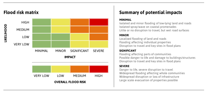
For coastal, as well as river, surface water and groundwater flooding, we use this simple matrix of risk to communicate our national overview of the RWC scenario for coastal flood risk to government and the emergency response community in the Flood Guidance Statement.
We use the RWC scenario so that people can be best prepared for what we assess as a reasonable expectation of the worst flooding impacts – a ‘prepare for the worst but hope for the best’ approach.
What did we do for coastal flooding during Storm Eunice?
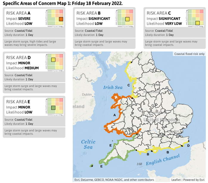
For the coastal RWC to happen we need large waves, storm surge and astronomical high tides to combine at any particular coastline to cause breaches of coastal flood defences leading to coastal flooding of communities and infrastructure. Figure 7 show the areas highlighted at being most at risk ahead of Storm Eunice.
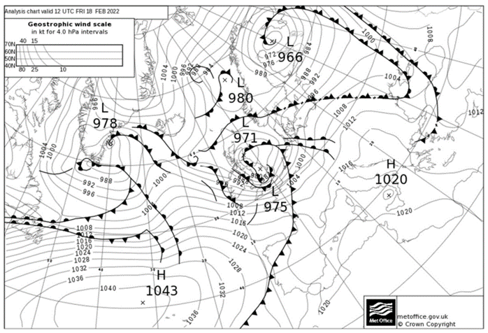
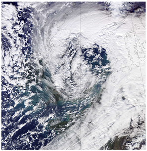
Alongside our forecasting partners in the Environment Agency, Natural Resources Wales and the Met Office, the Flood Forecasting Centre gave 5 days' lead time notice to the Emergency Response community, the UK Government and the Welsh Government of a potentially significantly impactful storm – subsequently named Storm Eunice (see Figures 8 and 9). This notice was communicated in the Flood Guidance Statement (based on the RWC scenario) issued on the morning of Monday 14 February 2022. Bear in mind that storm Eunice did not even exist as an identifiable weather feature at that point, only that Met Office atmospheric model forecasts were predicting its development over the Atlantic in the intervening days.
Giving five days’ notice of a potentially impactful storm allowed forecasters and Flood Incident Managers from the FFC, EA, NRW and the Met Office to instigate and participate in National Flood Incident Management meetings with emergency teams in national governments, including with government ministers, to ensure that all the necessary Flood Incident Management resources were put in place and actions taken to keep people, properties, businesses and infrastructure like roads and railways as safe as possible from coastal flooding before, during and immediately after Storm Eunice.
Storm Eunice Coastal Flooding Impacts
As mentioned earlier, for the RWC coastal flooding impacts to be realised, the large waves, surge and astronomical high tides must combine and coincide with each other.
Thankfully, during storm Eunice the worst of the storm surge didn’t quite coincide with the time of high tides, but it was very close with a matter of minutes making all the difference. Even though the RWC coastal flooding impacts were not realised, the Emergency Response community were prepared.
About the Authors

Deb Cooper a Chartered Water and Environmental Manager who specialises in real-time coastal forecasting in the Environment Agency. Deb leads on the real time forecasting developments for the east coast of England.
During her career Deb has provided the coastal expertise to develop the Environment Agency’s multi-million pound Incident Management Forecasting System. She also has an operational role as a Lead forecaster for East Anglia.
Keith Fenwick is a Senior Meteorologist at the Met Office Flood Forecasting Centre. He began his career as a weather observer before specialising in military aviation forecasting working alongside the Royal Air Force and has served in the Falkland Islands and Gibraltar.
Keith joined the Flood Forecasting Centre when it was a pilot project in London before it became fully operational at the Met Office headquarters in Exeter, where he continues to work today.


