
Flood forecasting factfile
Hello, we’re Jo and Alan and we are Flood Forecasters at the Environment Agency. In this blog we’ll hopefully give you a bit of insight into what river flood forecasting is, and how it fits into the broader picture of informing and warning people before, during and after a flood incident. We will also cover some of the technical background to flood forecasting that allows us to deliver this service.
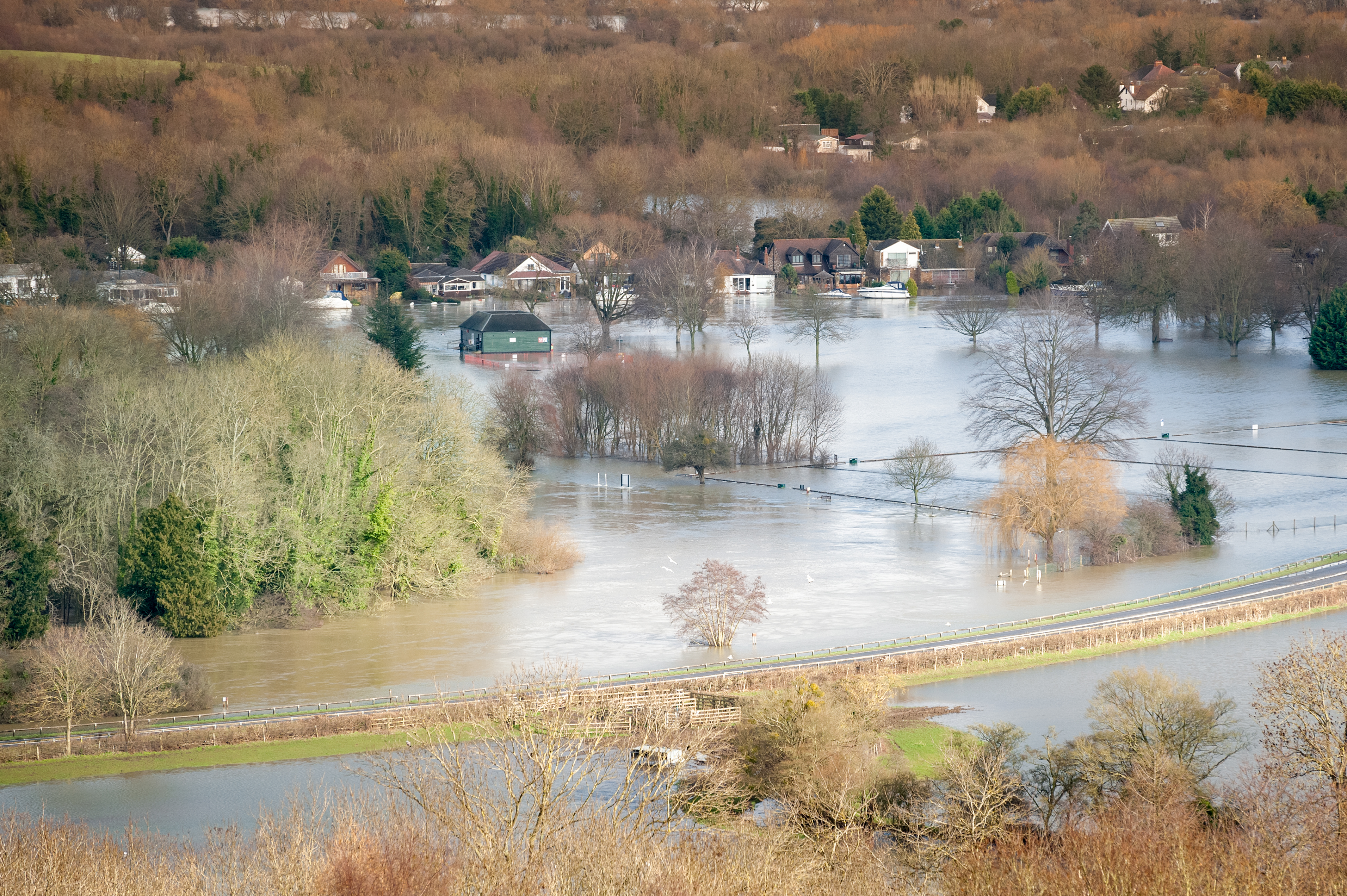
Early warning of flooding enables people, businesses and organisations to take action to reduce the impacts and stay safe. Flood forecasting is an important part of this warning service and in England covers river, coastal, groundwater and surface water flooding sources. We can use flood forecast information to assess the likelihood of an event, the scale of the flooding and where it may occur.
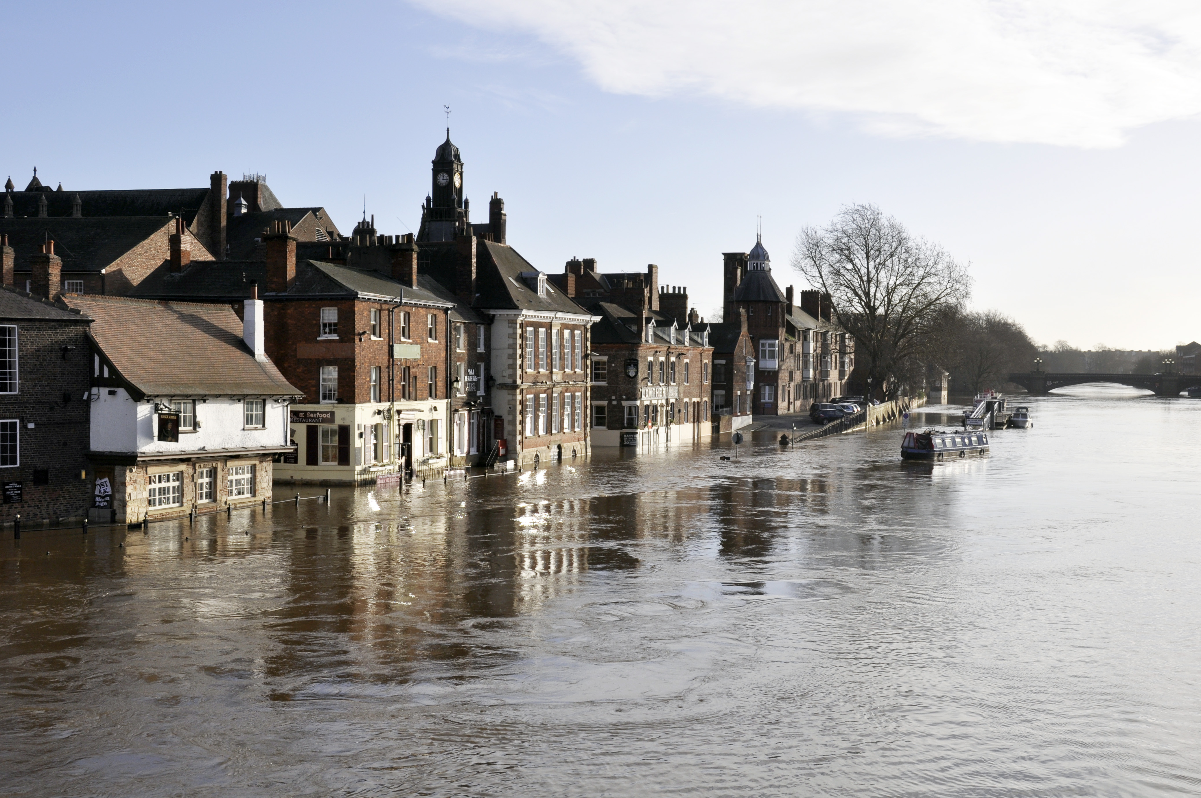
The most recent UK Climate Projections confirm we will experience wetter winters and drier summers, with an increased likelihood of more intense rainfall leading to flooding. Accurate flood forecasting will help us to make effective decisions early to save lives and livelihoods. We can use this information to reduce exposure of extreme hazard to the public, operate assets including the Thames Barrier, other defences and pumps, mobilise the military and warn/inform communities in a timely fashion.
What makes up a river flood forecast?
We need to be able to provide information on what we think river levels and flows will do following heavy rainfall, and this really is a partnership across a number of organisations (Figure 1).
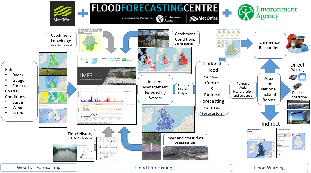
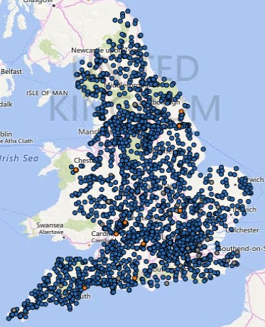
The Met Office gathers atmospheric data from satellites, radar and rain gauges to produce rainfall forecasts, using its numerical weather prediction (NWP) model. We use rainfall observations and forecasts combined with observed river levels from the thousands of river gauges in our telemetry network across England (see Figure 2), as inputs into our computational models. These gauges transfer data typically once or twice per day, however, during periods of heightened flood risk can be transferred in real time – meaning as quickly as every minute. We need to know the amount, distribution, intensity and timing of the rainfall.
Catchments have different characteristics; some are large, rural and groundwater fed and therefore respond slowly to rainfall. Others are very small, urbanised and respond very quickly to rainfall. It’s really important that we understand the topography, geology, soil, urbanisation and recent ground conditions, such as soil moisture of each of these different types of catchments. Computational models use mathematical equations to represent these catchment conditions and this allows them to model where the water will go and provide an output as a river flow or level. The Environment Agency uses a variety of different types of models, ranging from simple rainfall runoff models to the most sophisticated hydrodynamic models. These are dependent on the type of catchment we want to model.
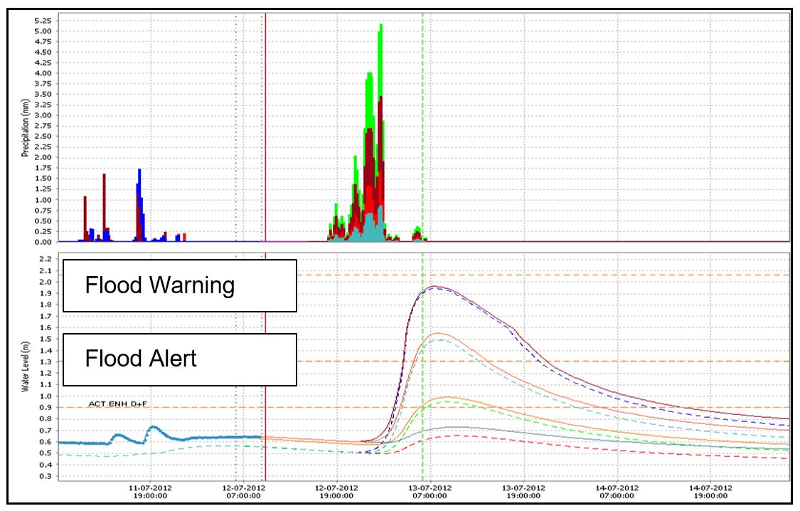
Using these model outputs, we are then able to provide a local flood forecast for all river level sites that represent a flood warning area (community). We use flood alarm levels to alert us when a river level is either forecast or observed to rise and flood particular areas. See Figure 3 for an example of the hyeto (rainfall) – hydrographs (flow) a model will produce, using rainfall as input and flow/level as output. You can see the alarms levels displayed as a horizontal line. These alarms then enable our flood warning officers to issue flood warnings to areas that are likely to flood either by rivers or the sea.
Types of river models we use
The type of model we use depends on the catchments characteristics. In upper catchments and/or smaller catchments (which are often called flashy catchments) river flows are highly dependent on the location and intensity of the rainfall. Generally, if you experience very heavy rain over these very small catchments it will lead to flooding. Because of this particular characteristic, our flood forecasts are very dependent on the rainfall forecast, there is little time for the models to run on observed data as the river levels respond almost immediately to the rainfall. These are often called rainfall- runoff models – as they do exactly what they say on the tin. They use rainfall inputs to provide forecast runoff (river flow/level) as outputs. With these models we generally only have confidence in the outputs up to about 6 hours ahead, as they are reliant on rainfall data and are quite simplistic in the way they model catchment characteristics.
In middle and lower catchments, forecast flows are moved down the catchment via hydrological routing models. These are simple models that use a method called the Muskingum-Cunge method of flow propagation to transport water downstream. River flows are converted into levels by using rating equations.
In more complex catchments, full hydrodynamic models are used. Extensive survey of the reach and floodplain is carried out and incorporated into the model, and the model also has the ability to deal with multi-directional flow, complicated structures and floodplain dynamics.
Generally, flooding will occur in complex large catchments as a result of very heavy rain over long timescales in the upper reaches of these catchments. However, it is still very important to analyse the rainfall that occurs further down the catchment as this can affect timing of river peaks.
Forecasts models need to be highly sophisticated to cope with the complexity of flooding impacts. We need to understand in-bank and out-of-bank flow, the impact of flood defences on flood flows, what happens when defences overtop and when flood storage locations fill. Downstream conditions are also important as in some locations high tides or other larger rivers can acts as a block for flood water exiting the catchment.
Any real-time operational flood forecasting model is fully calibrated (tested) before use. We use (quality checked) historic data to run the models ‘as if live’, for each flood event to ensure the model can replicate past flood events accurately. As part of the calibration stage the model developer is also required to test if the model is unduly sensitive to rainfall and likely to cause false alarms that can undermine future readiness to respond to flood warnings. We continually re-calibrate our models as part of our maintenance programme and develop new models to improve our service.
What are the types of activities a river flood forecaster will do?
Flood forecasters continuously monitor river and rainfall conditions and use these as data inputs to our river forecast models. We can get signals of heavy rainfall up to 10 days in advance and by feeding these into our models we can use the outputs for planning purposes. We use best estimate and reasonable worst case scenarios to give us a national summary of what type of flood event we may be looking at. The 5 Day Flood Risk is issued daily by the Flood Forecasting Centre.
There can be high uncertainty in location specific flood forecasts because of the factors explained in this blog, such as rainfall forecast and current catchment conditions. During flood events, flood forecasters continuously run flood models and assess and interpret their outputs to provide clear and timely advice to inform decision making and help people to stay safe.
Longer term, seasonal forecasts are used within the Environment Agency to help us plan our rosters and maintenance schedules.
This blog has focussed on river flood forecasting. We also forecast for estuary and coastal flooding which we feel warrants its own dedicated blog in the future; so watch this space.
Below are a list of activities that an operational flood forecaster will undertake during their shift. Flood forecasters across England will work as a team to provide the most up-to-date information during a flood event and work closely with Flood Warning Duty Officers to alert the public and partner organisations.
Before the rain arrives:
- Assess weather products
- Monitor current river level conditions and run models using forecast rainfall.
- Talk to the weather forecasters for more detail
- Investigate potential impact of forecasts
- Communicate risk with partners and the public
As the rain arrives:
- Monitor weather radar for areas of heavy rainfall
- Asses how rivers are responding to rainfall
- Assess and interpret the model outputs to determine confidence in the forecast
- Communicate risk with partners and the public
As the rain falls and the rivers respond:
- Monitor weather radar for areas of heavy rainfall
- Asses how rivers are responding to rainfall
- Continue to assess and interpret the model outputs to determine confidence in the forecast
- Forecasting for threshold crossings
- Recommend Flood Alerts and Warnings
- Regular updates relating to peak levels and timings
Where can I find more information?
Flood Information is available on the GOV.UK website:
- Flood Information Service – use this service to find out if you are in an area at immediate risk of flooding or at risk of flooding in the next 5 days, to sign up for flood warnings, or to find out how to get the flooding history for a property
- Check the long term flood risk for an area in England – use this service to find out: the flood risk for an area in England, the possible causes of flooding and how to manage flood risk
- In many flood risk areas, you can sign up for flood warnings. These warn of the risk of flooding from rivers, the sea and groundwater. You’ll be alerted by phone, email or text when flooding is expected
- The best way to protect yourself from flooding is to know what to do in advance. Download and save a simple Prepare, Act, Survive Plan so you’ll know what to do when there’s a flood warning in your area
- Check the latest flood situation online https://flood-warning-information.service.gov.uk/warnings
- 5 Day Flood Risk for England and Wales
- Rivers and Sea Levels in England
- Flood Forecasting — A National Overview for Great Britain by C. Pilling, V. Dodds, M. Cranston, D. Price, T. Harrison & A. How (2016)
How to stay safe in a flood?
Our Prepare, Act, Survive Plan includes:
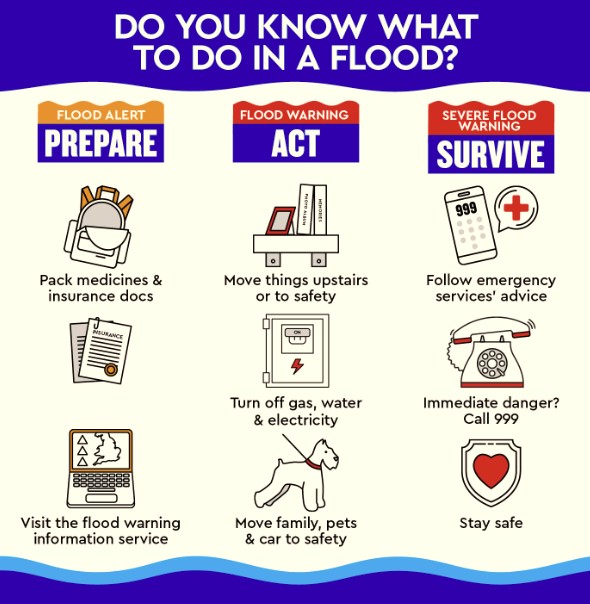
- Prepare a bag that includes medical and insurance documents
- Know how to turn off your gas, electricity and water
- Check your insurance to make sure you are covered for flood damage. If you rent your home, it is your responsibility to have insurance for your belongings
- You can make changes to your property that will help you to get back to normal more quickly after a flood and reduce the damage flooding can do. This includes things such as laying tiles instead of carets, moving electrical sockets higher up the wall or fitting flood protection products
- If you are flooded, call 999 if in immediate danger and follow advice from emergency services
Facts about flooding – Did you know?
Impacts of Climate Change
Over the past decade we have already seen more extremes in our weather, leading to increased flooding – the risk of flooding will increase with population growth and climate change. This year alone, we have experienced a number of flood events in the UK and worldwide, and only this summer severe flooding devastated parts of Western Europe, Japan and most recently the USA.
In 2020 the EA published its Flood and Coastal Erosion Risk Management strategy for England, which sets out the vision to be a nation resilient to flooding and coastal change – today, tomorrow and to the year 2100. In order to do this one of the ambitions is to be a nation ready to respond and adapt to flooding and coastal change.
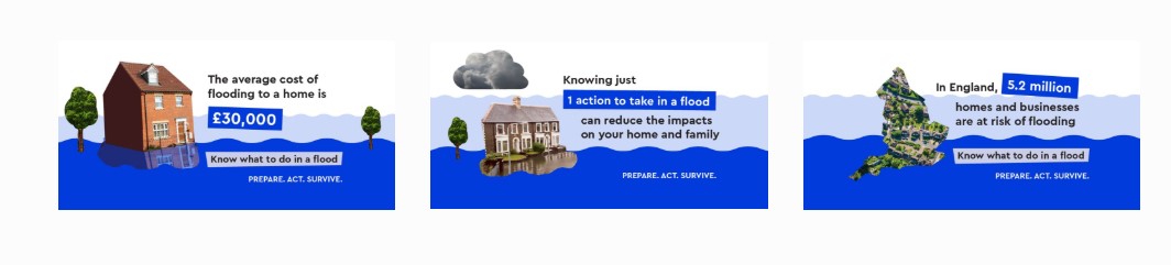
Approximately 2.4 million properties are at risk of flooding from rivers, the sea or both in England and Wales. Almost half a million of these are at significant risk (i.e. 1 in 75 years or greater).
Flood forecasting plays a vital role in enabling us to prepare for a flood event and help to keep people safe during a flood.
About the authors
Jo Coles and Alan Smith, Environment Agency
 Jo Coles is a Chartered Scientist and Fellow of the Royal Meteorological Society with a background in meteorology, operational flood forecasting and flood incident management.
Jo currently works at the Environment Agency in the Evidence and Risk department as a Senior Team Leader, leading a national team of highly skilled flood modellers and forecasters. She also has an operational role as a National Flood Forecasting Duty Manager.
 Alan Smith is a modeller specialising in real-time (forecasting) modelling at the Environment Agency. Alan leads a national team of highly skilled modellers and forecasters who share their knowledge and collaborate to deliver a variety of work.
In his career, Alan developed the forecast model in operational use for the novel “moveable weirs” flood defence scheme in Leeds and helped deliver the Web Portal of the Environment Agency’s multi-million pound Incident Management Forecasting System.
Alan lives in Yorkshire with his young family.


