From Hurricane Humberto to Storm Amy - what's in a name?
by Kirsty McCabe and Eleanor Pinches
Stormy weather in the UK is often given a name, to make messaging clearer and ultimately save lives. Each year, the UK's Met Office, Ireland's Met Éireann and the Royal Netherlands Meteorological Institute (KNMI), the Dutch national weather forecasting service, release their list of storm names for the season ahead. However, messages can get mixed, espeically when the media decides to jump the gun on naming a storm or when we get the remnants of a hurricane heading our way.
Let’s clear this up. We will not experience a hurricane any time soon in the UK. Hurricanes transition to extratropical cyclones by the time they hit the UK, and instead ‘arrive’ on our shores in a very similar form to our usual low pressure systems, perhaps bringing a little warmer (tropical maritime) air and more moisture than normal.
At the end of September 2025, there were two hurricanes - Humberto and Imedla - in the North Atlantic. Having two hurricanes in the Atlantic at the same time is not unusual, but Humberto and Imelda were very close together. And this proximity led to an interaction called the Fujiwhara effect, causing the cyclones to dance or rotate around one another. And it was the interactions of Humberto and Imelda's wind fields that led to the birth of Storm Amy — a distinct feature in the jet stream and the first named storm of the season.
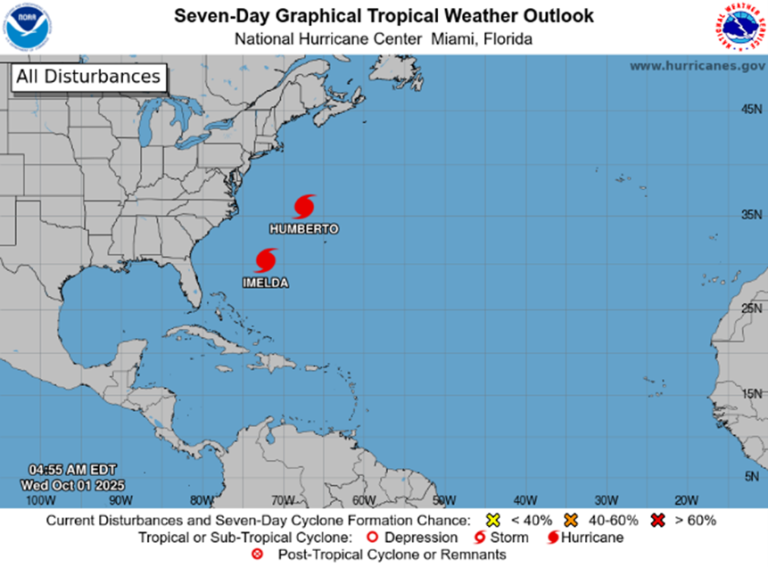
These two tropical cyclones rank 10th in the list of closest named storms since 1966, with 582 miles between the hurricanes. When cyclones get close enough, less than 900km (~560miles), their wind fields can interact with one another in a process called the Fujiwhara effect. The Fujiwhara effect can cause cyclones to ‘dance’ or rotate around one another and sometimes even merge.