
A traveller's guide to La Paz, Bolivia
Disembarking the plane in La Paz, Bolivia will take your breath literally and metaphorically away. The city has the highest elevation of any government city in the world, at an altitude of 3,650m.
La Paz is situated in western Bolivia, on the ‘altiplano’, an extensive highland plateau between the western and eastern ranges of the Andes. La Paz is built in a canyon carved out by the Choqueyapu River and is a drainage basin of the Amazon River.
Although La Paz lies just 16° south of the equator, its great altitude results in a cool climate. Regardless of the time of year, the average temperature in La Paz varies by just a few degrees. Daytime temperatures tend to be between 13-19°C, with October and November the warmest months. However, the city experiences a significant diurnal temperature variation. Depending on the exact altitude and the time of year, temperatures typically fall by 10-16°C at night. On the suburbs of La Paz lies El Alto at 4,000m, where the average minimum temperature from May until September is below freezing. Even in the warmest month, the average temperature remains below 10°C at altitudes above 4,000m. The maximum temperature recorded in La Paz was 27.0°C, with the coldest-ever temperature dropping to -12.5°C. Generally, precipitation is low, with the city commonly experiencing showers during the summers and drier winters. In total, La Paz receives around 250mm of precipitation each year, with more than two-thirds of the total falling from December to March, with the risk of destructive mudslides high at this time of year. February and March are the cloudiest months, with less than 5 hours of sunshine daily.
Although central La Paz is based at 3,650m, rapid population growth means settlements span from 3,200m to 4,100m. El Alto is situated just a few kilometres west of La Paz and is the second largest city in Bolivia, with a population close to 1 million. The lack of oxygen available can cause visitors to suffer from altitude sickness. Acclimatisation can take a few days, although exercising or walking uphill can still prove challenging, even after weeks of living there.
FIFA banned official football matches in stadiums at altitudes higher than 2,500m because of the health risks associated with lower oxygen pressure. However, intense lobbying by Bolivian authorities excludes La Paz’s Hernando Siles Stadium from the agreement, making it the highest-certified Olympic stadium in the world. Another outcome of the high altitude and low oxygen means that making a cup of tea is a little quicker, with water boiling at 88°C (190F) in La Paz.
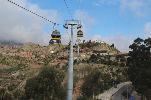
In 2014, La Paz was named one of the New7WondersCities. One of La Paz’s most exciting projects is ‘Mi Teleferico’ – which translates to ‘My cable car’. The system opened in 2014, and there are currently three lines in operation, with six more lines being planned. What initially started as a project to reduce road congestion, taking the cable car is also the most spectacular way to view the city, day or night.
San Francisco Church is one of the city’s major landmarks and dates back to 1743. It is located north of ‘El Prado’, one of the city’s main streets, and is a popular meeting place for both tourists and locals. Mount Illimanni, at 6,402m, provides a stunning city backdrop and can be best viewed from the Kili Kili viewpoint in central La Paz. Roughly a 12-hour drive from La Paz lies Bolivia’s most famous attraction, Salar de Uyuni, the world’s largest salt flat, covering an area half the size of Wales. Yungas Road is another well-known attraction, perhaps for not the best reasons. Known globally as ‘Death Road’ or ‘the world’s most dangerous road’, it is one of the only routes that connects La Paz to the Yungas region in the northeast of Bolivia. Despite the name, the road draws more than 25,000 thrill-seekers each year who traverse the road by bike.
Other beautiful sites you should consider visiting whilst in Bolivia include Lake Titicaca, the largest lake in South America that straddles the border between Peru and Bolivia. In Andean belief, Titicaca is the sun’s birthplace and is surrounded by numerous Inca ruins. During the day, temperatures tend to reach the high teens. However, the warmth quickly disappears at night, with average lows of -7.5°C during July. Madidi National Park is a wonderful place to travel to experience Amazon wildlife. Based in the country’s northeast, tourists tend to fly into Rurrenabaque before taking a 3-hour boat ride up the Madidi River. Once you have arrived, retreat in an ecolodge for a few days, with the chance of hearing the calls of a jaguar or catching a glimpse of the vibrantly coloured macaws. Here the climate is much more tropical, with an average temperature of 26°C and 716mm of precipitation yearly.
Although Bolivia tends to be a path less travelled, the country provides a vast variety in climate, geography and culture compared to its other South American neighbours, with spectacular scenery, and fun-filled fiestas, not to mention the warm and welcoming locals. ¡Vamos! (or in English, Let’s go!)
Photo: La Paz’s cable car system is one of the most popular and convenient ways to get around the city Credit: Chloe Moore


