
An ill wind: A look back at the Great Storm of 1987
Mark Riddaway tells the story of the most famous British weather event in recent history.
It is a measure of the benign nature of the British climate that the early hours of Friday, 16 October 1987, should be seared so deeply into the nation’s consciousness. Viewed alongside Hurricane Katrina (over 1,800 dead and almost an entire city destroyed), the Pakistan floods of 2010 (200,000km² underwater and 20 million people directly affected), or just about any overseas weather catastrophe extreme enough to trouble our newspapers, the events of that blustery autumn night appear distinctly underwhelming. But even though anyone living in a region regularly threatened by Atlantic hurricanes, Pacific super-typhoons or vast families of tornadoes would doubtless laugh at the hyperbole, to any British person who lived through it, what we experienced in October 1987 was and will remain the ‘Great Storm’.
Viewed purely through the prism of British history, the name is entirely appropriate. The last storm to have had so deep and widespread an impact occurred as far back as 1703—this was also known as the Great Storm, proving that originality is even rarer in this country than extra-tropical cyclones. According to the Met Office, the wind speeds experienced in the south of England in 1987 made our Great Storm a “once in 200 years” event. Similar wind speeds would be expected in the far north of Scotland every 30 or 40 years, as the Hebrides, Orkney, and Shetland sit close to the main Atlantic storm tracks, but that’s one good reason few people live there.
Numbers alone never tell the whole story—the night in 1979 when the English lowland wind speed record of 118mph was set on the remote, rocky headland of Gwennap Head in Cornwall is rarely the cause of lengthy magazine retrospectives—but some of the data from 1987 are worth repeating. The most powerful gust on the UK mainland that night was felt at Shoreham-by-Sea in West Sussex, where the wind reached 115mph at 3:10 am on 16 October, while five other weather stations around the south coast recorded gust speeds of more than 100mph. Northern France also took a heavy hit from the storm, with Pointe du Raz in Normandy experiencing the highest gust of the entire event—135mph.
Although high winds in coastal areas are fairly commonplace, the 1987 storm was most remarkable for some of the numbers recorded in more sheltered areas far inland—areas that are among the most densely populated in the UK. For example, Gatwick Airport recorded a gust of 99mph at 4:30 am, while a gust of 94mph hit the London Weather Centre in High Holborn, right in the heart of the city, at 2:50 am. In fact, across the southeast, gusts of more than 80mph were being continually recorded for three or four hours—an unprecedented bombardment for a region with the most sedate climate in the country.
High wind speeds were not the only remarkable aspect of the storm—it was preceded by some spectacular temperature rises and was followed by record-breaking increases in pressure. As the storm’s warm front passed over England on the evening of 15 October ahead of the high winds, the temperature at Heathrow Airport rose from 8°C at 6 pm to 17°C at 9 pm. At Mortimer, in Berkshire, the temperature rose by almost 8°C in just 20 minutes from 10:20 pm, while hourly increases of more than 6°C were experienced in numerous locations south of a line that stretched all the way from Dorset to Norfolk. In the wake of the storm, temperatures fell with similar rapidity, and barometric pressure rose remarkably. Over much of southern England, increases of more than 8mb per hour were experienced, while at Portland Royal Naval Air Station in Dorset, a rise of over 25mb between 3 am and 6 am was the largest three-hour increase ever recorded in the UK. This was a storm that, by almost any measure, was far from ordinary.
Most people who lived in the south at the time will vividly remember the experience of waking up to a completely altered landscape. Roofs had been blown off, with tiles scattered like confetti; cars had been flipped over, windows shattered, fences toppled; a Sealink ferry had been deposited on a Kent beach; thousands of homes had been left without power, some of them for several weeks. However, the death toll of 18 people, most of them killed by falling debris, was fairly low considering the extent of the damage, thanks mainly to the storm’s serendipitous timing—had it arrived at any time other than the dead of night, the carnage hardly bears thinking about.
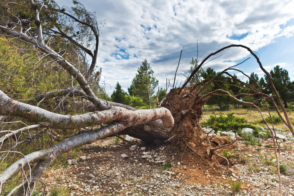
Perhaps the most depressing sight when the sun rose that morning was the massive, indiscriminate deforestation of large swathes of the region. Previous weeks had been extremely wet, so the ground was soft and pliable, and the autumn leaf fall had yet to start in earnest, meaning that tree canopies provided a wide surface area for the wind to attack. Any trees not protected by the sheltering effect of deep woodland were liable to be plucked from the soil. English towns and villages often have a small number of ancient trees at their heart—oak, ash, yew, cedar—which are as old as the streets that cluster around them and as deeply rooted in the town’s history as they are in its soil. The emotional impact of the destruction of so many of these trees was widely felt. In one of the most distressing instances, the town of Sevenoaks in Kent was reduced to one oak, as six magnificent eponymous trees instantly became anonymous timber. Over 15 million trees were destroyed, amounting to over 4 million cubic metres of timber.
There were bright moments. My school closed for several days after the roof of our maths block was redistributed over the playground. The extent of the trauma experienced by those who lost their homes, cars or gardens that night was slightly offset by the joy of several hundred teenagers who got to spend that Friday watching Neighbours and playing Super Mario Brothers rather than struggling over simultaneous equations. Such happy stories were, admittedly, few and far between.
Over the coming days and weeks, a media storm, containing almost as much wind and bluster as the actual storm, would blow up over the failure of the Met Office to provide adequate warning of the coming carnage. But, just as nature abhors a vacuum, so the national press abhors a disaster without a scapegoat—and the BBC weather presenter Michael Fish was chosen to play that unenviable role. Providing clear evidence for why TV weather forecasters should concentrate on clarity and accuracy rather than public engagement and personality, Fish joshed with his viewers that Thursday lunchtime about a woman who had phoned the BBC worried about a hurricane coming—seemingly a reference to Hurricane Floyd, which at that point was gathering strength out in the Atlantic. He reassured her, quite correctly, that a hurricane was not on its way, then qualified this by saying, “Actually, the weather will become very windy.” His mistake was in the levity of his approach and the jauntiness with which he said, “Don’t worry...” Worrying, it turned out, would have been an entirely appropriate response.
The real failure was not Michael Fish’s but that of the Met Office as a whole, which was taken aback by the storm’s speed, direction and severity. This was, however, entirely understandable. Even now, despite the technological advances of recent decades and significant changes in storm forecasting triggered by the 1987 disaster, sophisticated computer models struggle to accurately predict the explosive development of mid-latitude Atlantic windstorms. This is partly due to the relative absence of observations from the middle of the ocean and partly because such storms are so bafflingly complex and erratic. Moreover, in 1987, data from the Atlantic were even less plentiful—exacerbated by the fact that the Met Office’s Bay of Biscay weather ship had recently been decommissioned due to budget cuts.
The storm was the consequence of the unhappy meeting of several different weather systems. Warm air was being forced eastward by Hurricane Floyd, which threatened the coast of the USA, while sea surface temperatures in the Bay of Biscay area also happened to be warmer than usual. When very cold air moving south from Iceland entered this region of the Atlantic, the result was an exceptionally large temperature gradient. Meanwhile, a large area of low pressure had been lingering to the west of Ireland and the northwest of Spain, the associated frontal waves of which had been soaking the British Isles for several days, causing fairly severe flooding. When this low-pressure area hit the oversized temperature gradient, the result was a rapidly deepening depression and a storm of bewildering energy. The final piece in this rather nasty jigsaw was a particularly strong jet stream, located much further south than usual, which helped to propel the storm at exceptional speed towards the UK. Subsequent research has identified the most damaging element of the Great Storm as a ‘sting jet’—an entirely new classification for a small, fast-moving and unpredictable storm with a distinctive hook-shaped section, which at the time could not possibly have been predicted by forecasting models.
For several days, the Met Office had been forecasting severe weather for that Friday, but the emphasis had been more on heavy rain than on high winds. By 15 October, forecasters were warning of the approach of a major depression but were expecting it to track to the south of the UK, missing the mainland. Warnings of severe gales in the Channel were issued, but the UK mainland was not thought to be threatened. In his infamous lunchtime broadcast, Michael Fish stated, “most of the strong winds, incidentally, will be down over Spain and across into France”.
By the time most people went to bed on Thursday night, TV and radio forecasts continued to focus on the expected rainfall. Then, finally, the first severe weather warning from the Met Office, which came close to anticipating the nature and severity of what was to come, was issued to the authorities at 1:35 am, only hours before the worst of the damage was wreaked and far too late at night to be much use to a nation that was, for the most part, already tucked up in bed.
Some positives did emerge from the storm. A major internal inquiry was undertaken at the Met Office, which involved independent assessors to analyse what had gone wrong. As a result, an increase in the quality and quantity of data gathering out in the Atlantic was called for, as were changes to computer models, training and severe weather warnings. The resulting reforms would make the country far more prepared for major storms in the future.
Even the brutal deforestation of large parts of the south brought a few chinks of light. Quite literally, some of the more enlightened landowners, particularly the National Trust, used the loss of dense, mature canopies to re-think some aspects of woodland management, giving other smaller trees and plants a chance to thrive in their stead.
I’m sad to say my school had a new roof back on the maths block in no time. Not even the worst storm in almost 300 years could stop those simultaneous equations for long.

