
Why do clouds form? Part 3: Large and slow; small and fast
In the two previous articles I have looked at how adiabatic processes result in a decrease in pressure leading to a lowering of temperature. In the real atmosphere, pressure changes most quickly when moving vertically, falling as you go up and rising as you go down. Therefore, temperature generally falls with height. This cooling eventually leads to condensation. This, in turn, leads to the release of large amount of energy and the formation of cloud. Similarly, decreasing height results in an increase in both pressure and temperature, leading to evaporation and cloud dissipation.
There are other processes involved but as a first approximation, to produce or disperse cloud in the real atmosphere, you need to make air rise or fall. As we are looking at cloud formation, I shall focus on processes that cause air to rise.
I shall divide the processes into two large groups. One group covers large amounts of air rising slowly, the other small amounts of air rising quickly. In the real atmosphere, there are many interactions between these processes that complicate matters. However, that can be said about most things operating in the real atmosphere so just go with me on this!
Large and slow
The most obvious example of ‘large and slow’ is the vertical motion associated with fronts. A front is a boundary between two air masses. The air masses have different characteristics; wet or dry, warm or cold. This means that they will have a difference in density. In a warm front, the warmer, less dense air behind the front will rise up and over the cooler air ahead. In a cold front, dense cold air digs under less warm air. In both cases, as the air rises, it cools and cloud forms. These processes produce large areas of rain-bearing layer (stratiform) cloud often hundreds of kilometres wide and thousands of kilometres in length. The air is said to be ‘stable’ as it ‘wants’ to return to its previous state. The air needs to be constantly pushed by the wind in order to rise. If the flow ceases, the air sinks, and cloud dissipates. It returns to its previous state. The upward motion is slow, in the order of centimetres per second.
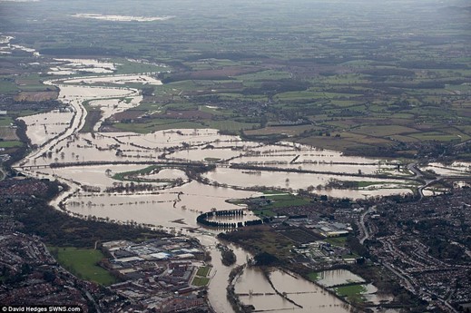
Rain falls when the drops are too heavy to be held up by the vertical motion in the cloud. Slow upward motion means small drops. However, there are a lot of small drops falling over a wide area for a length of time. If sufficient rain falls, then flooding may occur, and rivers can burst their banks and spread out over a flood plain. This happens relatively slowly, and while the damage can be immense, people can usually get out of the way.
Small and fast
The most obvious example of ‘small and fast’ is cloud produced by convection. On a day-to-day basis, the sun does not really heat the atmosphere. The energy passes through it and heats the ground. It is the ground that heats the air from the bottom up. This is an important distinction because it influences just about everything going on in the lower atmosphere. Interestingly, in meteorology, air temperature is measured in a temperature screen between 1.2m and 2m above ground level. The maximum temperature in the UK measured in this way is 38.7 ºC. But on almost every sunny summer day, the temperature measured at 5cm above the ground in direct sunshine will be higher!
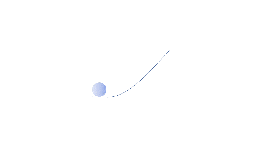
When an air parcel very close to the ground is heated from below, it becomes warmer than the air just above the ground. It becomes buoyant and starts to rise. As long as the parcel is warmer than the surrounding atmosphere, it will continue to rise. The vertical temperature profile of the real atmosphere can be obtained using instruments attached to a balloon. In the previous article, we showed that the temperature of our parcel at any height can be calculated using thermodynamics.
If the parcel is warmer, it will rise. If it is cooler, it will fall. If condensation occurs in a rising and cooling parcel, the extra heat released will make the parcel rise faster. Ultimately, the rise is limited by the real atmosphere. Sometimes this is at quite a low altitude, which results in small clouds. But, on other days, it can rise all the way to the stratosphere, and therefore big clouds!
Once given a push from below, by surface heating, for example, the air will continue to rise until it is ‘stopped’ by the atmosphere. It never returns to its original state. It is said to be ‘unstable’. Clouds produced in this way are known as cumuliform or ‘lumpy’. Fundamentally this is the difference between showers and rain. Not intensity, not duration but the type of cloud it falls from. Rain falls from stratiform cloud, and showers from cumuliform. Yes, I know you get just as wet but using the terms correctly is important. At least it is to me!

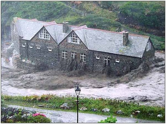
The upward motion within cumuliform cloud is more rapid than that found in stratiform cloud. It ‘holds’ water drops in the cloud and allows them to grow larger. When they fall, the large drops mean that the intensity of rain is greater, but it falls over a shorter time. Rainfall rates of 100 mm per hour are not uncommon in large showers or thunderstorms, but these rates are only maintained for a few minutes. If, for some reason, they persist, then flash flooding is likely. As the name suggests, this has a very short timescale and overwhelming drainage systems, both natural and human-made. It happens quickly and with great force. The flood at Boscastle in August 2004 is an example. The damage is caused as much by things swept along in the flow as it is by the water itself. All this can happen in a matter of minutes and so is difficult to anticipate. These are the kind of situations that are to likely become more common in this age of global warming.
Conclusion
Adiabatic cooling and warming is just one method by which cloud can form or dissipate. There are many others. Air can be cooled in other ways, for example contact with a cooler surface. Cloud can be formed by keeping the temperature constant and increasing the moisture content by evaporation from a water surface. As I said earlier these processes all work at the same time, making precise forecasting very difficult.
However, occasionally as a forecaster, the weather situation is such that you can do something really cool. When I was a forecaster at the now defunct Birmingham Weather Centre, I had such a day. I used the thermodynamics of adiabatic cooling to predict the temperature that cumulus cloud would form. The sun shone, the temperature rose and when we reached my temperature I looked out and a cloud appeared in a clear blue sky. If you don’t get joy out of that then I would suggest that forecasting is not the job for you!!
This is the last of three articles on how adiabatic processes lead to cloud formation. As I said at the start, this is neither a rigorous nor exhaustive treatment of the topic, but I hope you found it an interesting read.
If nothing else you now know why, if you wish to cool something, it is better to blow on it rather than to breathe. It is all down to ‘simple’ thermodynamics.
About the author
Frank Barrow retired from the Met Office in 2020, after a career of 39 years during which he worked as an observer in the 1980s, a forecaster in the 90s and, since 1996, as a trainer at the Met Office College. He describes the latter role as “fitting him like a glove”, so he stayed... for almost 25 years! During that time, he was involved in the training of the vast majority of current Met Office forecasters.


