
Exact date to stop believing weather headlines
From snow to heat, one thing as predictable as the changing seasons is online news headlines that promise the ‘exact date’ we will see extreme weather events in the UK, often weeks in advance. But where do these dates come from and how do you know if they are accurate? Over to the Met Office news team for the truth behind those headlines.
Forecasting uncertainty
Despite the certainty suggested in some online headlines, meteorology isn’t an exact science, and although forecast accuracy is improving (the Met Office’s 4-day forecast is as accurate as its 1-day forecast was 30 years ago), long range predictions come with in-built uncertainty. It’s this uncertainty that isn’t always captured by some online headlines.
“The weather by its very nature is chaotic. Small differences in conditions can have a significant impact on the forecast in the following days and weeks.
“It’s these small discrepancies which mean it’s nearly impossible to talk with absolute certainty about the specific conditions expected for an ‘exact date’ a few weeks away.”
- Met Office Senior Presenter and Meteorologist Alex Deakin
Where do the weather headlines come from?
The UK is one of the most challenging regions to provide robust longer-range information, as it is dominated by the atmospheric circulation over the North Atlantic, which is highly variable. While there tends to be a good deal of agreement between forecast models at a short range, differences increase at a longer range, highlighting the uncertainty in weather conditions further ahead.
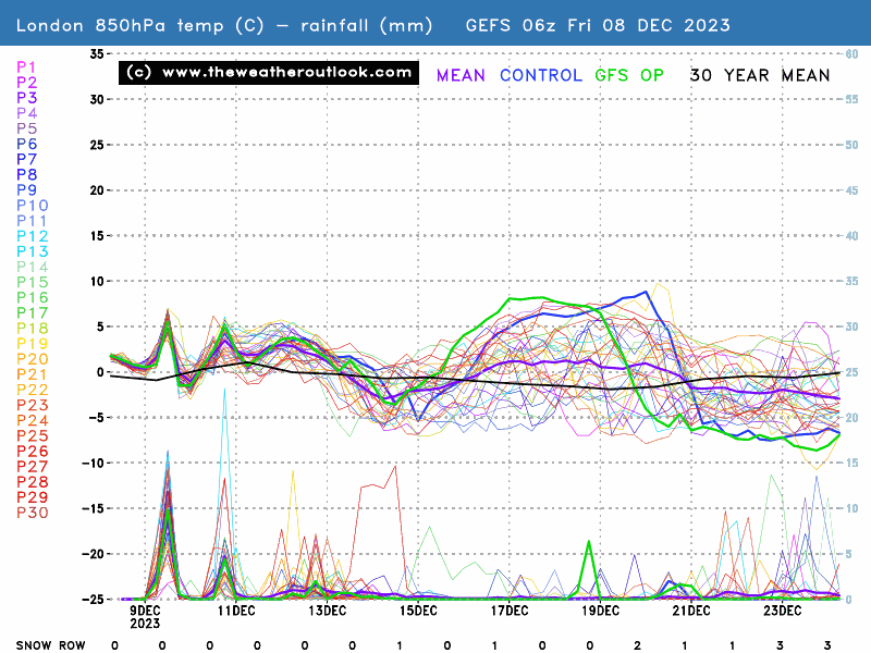
The upper plot shows forecast 850hPa temperatures which are approximately 1500m above sea level. They provide a way of checking how cold or warm the air mass is and aren't subject to diurnal (day to night) variation.
The lower plot shows forecast precipitation. The snow row displays the number of GEFS runs forecasting snow. This ranges from 0 to 33.
An individual weather chart from a specific model run will not provide a genuine balanced forecast, it’s the job of meteorological experts to capture the nuance between what different charts and models are suggesting, and then to create a forecast that demonstrates the most likely outcome as well as any uncertainties and intricacies.
However, forecast models from a range of professional organisations are available in the public domain for free and sometimes a singular model run, often for weather weeks away, gets used by some online outlets to suggest the ‘exact date’ certain conditions will occur. One-off, individual weather charts cannot represent a definitive forecast with anywhere near the certainty that some apply to them.
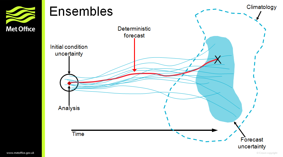
The Met Office uses ensemble forecasts to quantify uncertainties in weather prediction and estimate risks of particular events occurring. This means that rather than relying on one single model run, which takes a picture of the current atmosphere and attempts to model it into the future, the simulation is run hundreds of times from slightly different starting conditions.
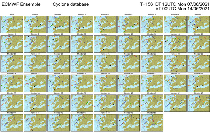
This means that expert meteorologists can look at the spread of scenarios ahead of issuing a forecast. If all the model runs are quite similar, then confidence is higher, but if they’re varied, then there’s lower confidence.
“While forecast accuracy is improving, there’s always an element of uncertainty when forecasts talk at longer ranges. What isn’t always captured in the headlines is this uncertainty, and why that exists in the forecast.
“In Met Office forecasts, we try to explain the levels of uncertainty and reasons for it in our in-depth output. This is particularly useful for those who like to look at a forecast at a slightly longer range.”
- Met Office Senior Presenter and Meteorologist Alex Deakin
For those that want to go in-depth into the weather forecast and the drivers of UK weather, the Met Office’s YouTube series Deep Dive and 10 Day Trend provides insight and explanation on the weather patterns of the UK.
Getting an accurate forecast
While the majority of reporting on the weather is fair and accurate, there are a few things you can do to make sure you’re getting the accurate information you need.
Some tips from the Met Office include:
- Check the source
- Check the weather charts
- Check for uncertainties
- Check the Met Office
Find out more about weather forecasting in the news media and how to get the information you need.

 © Ed Hawkins, University of Reading")

