
Weather Photographer of the Year: Setting the scene - mist and fog
Continuing our series of posts looking at some of the weather themes from previous years of Weather Photographer of the Year, regular guest writer Frank Barrow takes a look at mist and fog.
The difference between mist and fog
Mist and fog are common phenomena in the UK. They are both formed in the same way. The difference is set by an essentially arbitrary measure of the visibility within the mist or fog. If visibility is less than 10km it can be called mist, if less than 1km it is called fog. These figures were chosen with safety at sea and in the air in mind. Nowadays the importance of road transport means different limits are used in public service forecasts. The definition of mist remains the same, but fog requires visibility to be 200m or less.
|
|
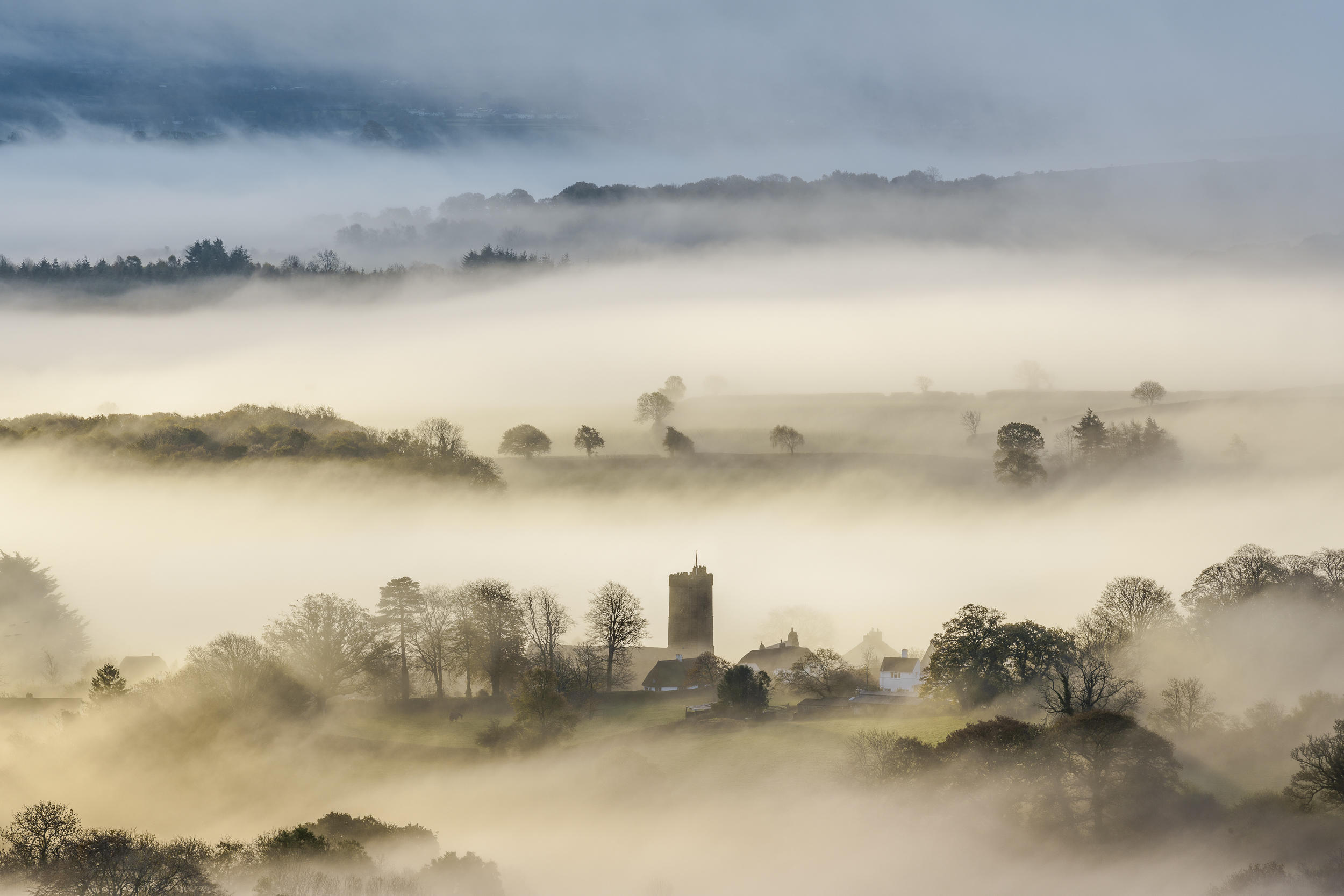
This image shows mist rather than fog. Thinking about images like this may be the inspiration for John Keats’ famous line in his poem 'To Autumn'.
|
So fog and mist are phenomena that lead to a decrease in visibility.
What do we mean by visibility?
In meteorology, we define visibility as 'the greatest distance at which an object can be seen and recognised in daylight.' The definition of visibility at night is probably the least useful in all meteorology, and a favourite of mine. The definition of visibility at night is 'the greatest distance at which an object can be seen and recognised if it was in daylight.' Honestly!
How do they form?
Mist and fog form due to condensation onto microscopic particles known as condensation nuclei. Condensation nuclei are all around us. We breathe them in and out without noticing, but without them, it is difficult if not impossible for condensation to occur.
In the UK it is very rare to see fog made of ice particles, our temperatures do not get low enough. When temperatures are below 0°C, the droplets become what is known as ‘supercooled’, below 0°C but still liquid. Supercooling is another of the myriad of strange properties of water. When supercooled droplets strike a surface they instantly freeze and build up as 'hoar frost' This is what we see on a ‘frosty morning’
|
|
In this image, hoar frost has been and is being deposited on the vegetation in the foreground. The fog clearly has no great depth as the rising sun can already be seen.
Incidentally, the observed visibility in this direction would be the distance from the observer to the windmill. |
The process of fog and mist formation is useful for identifying areas where mist and fog are most likely to occur. Two things are needed, moisture and some way of cooling the air until condensation occurs.
Sources of moisture are available in many locations. The limiting factor is usually cooling. The easiest way of cooling air in the atmosphere is to make it rise. Rising air forms cloud. However, except for air forced to rise over hills, this will not necessarily reduce surface visibility. Fog and mist are produced by cooling of the ground that spreads to no more than a few hundred feet above ground level. Surface cooling is due to the escape of longwave radiation to space.
Optimum conditions for the formation of ‘radiation’ fog:
Clear sky or just thin high cloud - Allows radiation to escape to space
Moist ground - Sources of moisture
Moist air in the lowest 100m or so - Sources of moisture
Light surface winds - A small amount of turbulence is useful
Favourable local topography - Cold air draining into hollows and valleys concentrates the surface cooling
The two images below illustrate these conditions,
|
|
This shows fog largely confined to the course of a river. Cold air drains down to the lowest level i.e the bottom of the valley. The river provides the moisture. Slightly less cooling and slightly less moisture result in misty conditions across the surrounding landscape The illumination from the low morning sun. accentuates the image. |
|
|
This image shows the limited vertical ascent of fog. Looking down on fog from high ground produces interesting imagery. Note the fog looks bright from above. It reflects light very efficiently. This is why conditions within the fog are often quite gloomy. |
Given that fog and mist are quite common phenomena, the process of fog formation is surprisingly complex. It requires a sequence of events.
Firstly, the cooling at the surface lowers the temperature of the air in contact with it. Dew is deposited. Turbulence forms a slight breeze that sustains the dew deposition. Surface temperature and dew point fall. Next, there is a temporary lull in the light surface wind. This results in condensation occurring in the air near the surface. Shallow fog forms. Visibility is still above all fog limits as the fog is below eye level.
|
|
This image shows shallow fog formed over an undulating landscape. Formation occurs preferentially as cold air drains into hallows
|
As radiative cooling from the surface continues, the fog deepens, and visibility drops to below fog limits for air and sea transport (<1000m). Most people would probably still describe this as mist. Eventually, the fog is deep enough to absorb all the radiation from the ground. Cooling now occurs at the top of the fog, trapping it and causing visibility to decrease to below road fog limits (<200m).
The cooling can also be achieved by warm air passing over a cold surface. In the UK that surface is usually the sea. In spring, sea temperatures are at their minimum. At this time of year, the North Sea is slightly odd. It gets colder as you move south with the minimum somewhere off the Lincolnshire coast. The classic situation is to have high pressure centred just to the west of Scotland. This draws warm moist air around the top of Scotland and down the North Sea causing fog and low cloud to develop. On the east coast of Scotland, this is known as ‘Haar’. When land cools at night it can push onto the coast and if geography permits push well in well inland. In the morning, it will ‘burn back to the coast’. How far it moves inland by night and off the coast by day is a ‘tricky’ thing to predict.
In fact, predicting when any type of fog will clear is not easy. The atmosphere ‘inside’ the fog has different properties than that outside. These conditions are very localised both in area and in height. I know from (bitter!) experience that the timing of fog clearance has the capacity to make any forecaster look rather silly from time to time.
There are other examples where moisture leads to a local decrease in visibility. Air forced to rise by winds and high ground produces hill fog. Precipitation itself and the increase in humidity caused by its evaporation can lower visibility. Snow of any significant intensity will lower visibility very rapidly.
|
|
This is an example of hill fog. Winds are blowing from bottom right to top left. This forces the air to rise and cool. Note there is no fog downwind of the high ground |
|
|
Here we see several processes working simultaneously. Shallow fog forming over the lake due to cold air drainage and the availability of water. The lake is probably sheltered from any wind by the surrounding high ground On the high ground air is forced to rise, producing hill fog |
As I said at the beginning of this article mist and fog are common phenomena. One reason they are regarded as common is that there are many ways for them to form. However, if you ask most people, ’What is fog?’ I think they are usually thinking of the radiation fog. Hence this has been the main focus of this article.
About the author
Frank Barrow retired from the Met Office in 2020, after a career of 39 years during which he worked as an observer in the 1980s, a forecaster in the 90s and, since 1996, as a trainer at the Met Office College. He describes the latter role as “fitting him like a glove”, so he stayed... for almost 25 years! During that time, he was involved in the training of the vast majority of current Met Office forecasters.
Header image credit: Richard Fox


