
Australian floods and triple La Niña
Rainfall totals were exceptional in parts of southeast Australia during 2022. Of course, Australia is no stranger to extreme weather, from tropical cyclones to extreme heat, wildfires and flooding. But record rainfall during the year led to widespread flooding across southeast Australia, with the flood crisis in New South Wales declared Australia’s most expensive natural disaster.
Looking at just the month of October 2022, both the states of Victoria and New South Wales saw their wettest Octobers on record, according to the Australian Bureau of Meteorology. The state of Victoria actually received its highest monthly rainfall total for any month of the year, with rainfall records here going back to 1900.
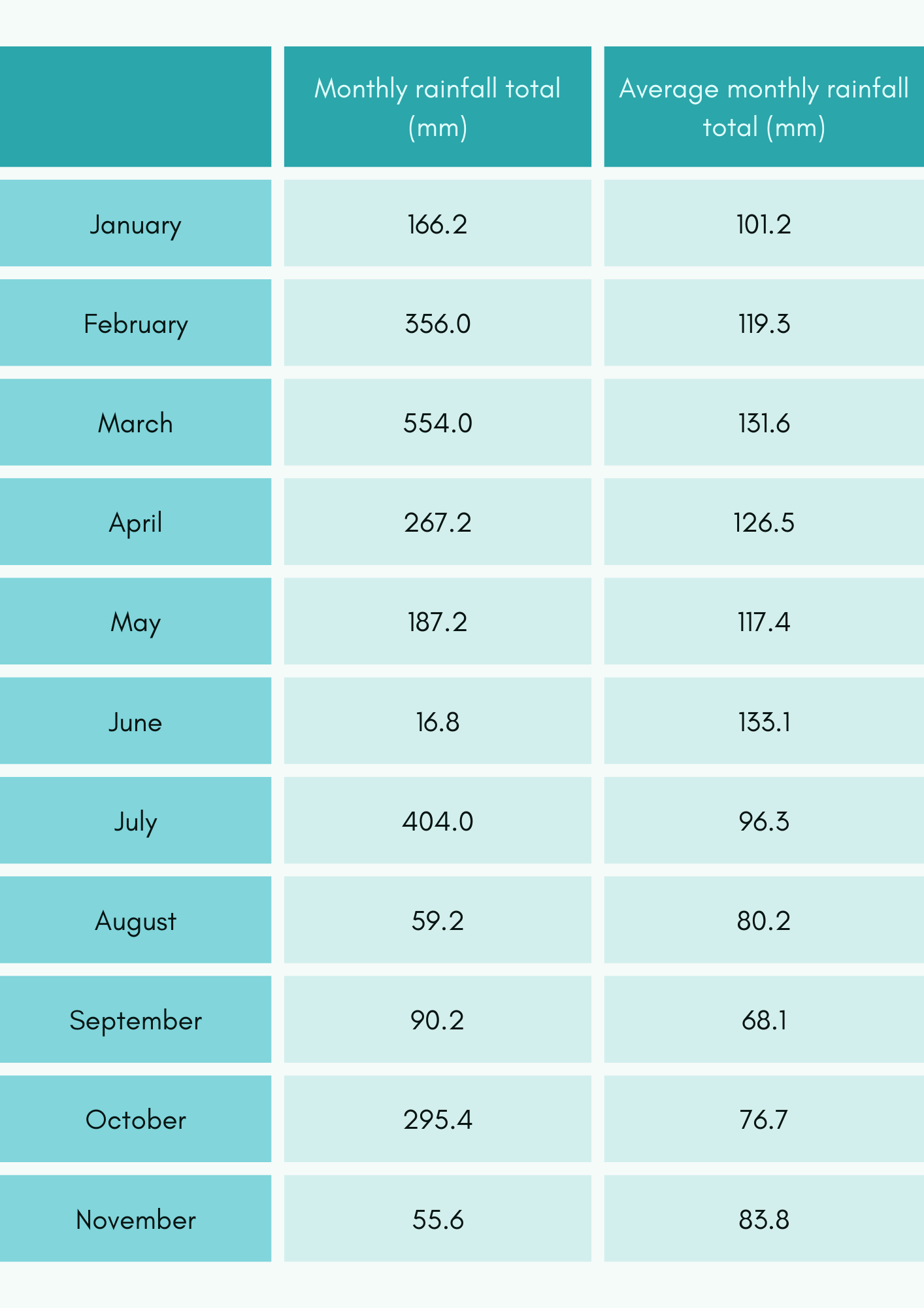
July 2022 was also extremely wet. Sydney Observatory Hill recorded 404mm of rain, over 4 times the average monthly July rainfall for this site (96.3mm). It was the wettest July on record for much of the east coast of New South Wales, including Sydney, with rainfall around 4 to 8 times the July average. This came just a few months after many areas in Greater Sydney saw their wettest March on record, with rainfall 4 to 5 times the monthly March average. Sydney Observatory Hill recorded 554mm of rain during March 2022, which was well above the monthly March average of 131.6mm.
Perhaps unsurprisingly, the Sydney Observatory Hill station recorded its wettest year on record before 2022 had even drawn to a close. It is worth noting that the annual rainfall records at this site go back to 1859, so there is a very long series of data for this site. To the end of November 2022, the site had recorded 2,451.8mm of rain, which is more than twice the annual average rainfall of 1213.4mm and almost 400mm more than the previous record of 2054.4mm, which was set in 1950. During the first 3 months of 2022 alone, there was 1,076.2mm of rain recorded at the site, which is more than the annual average rainfall for numerous places in the UK including Edinburgh, Scotland (784.29mm), Exeter, Devon (829.16mm) and Bude, Cornwall (905.71mm).
The table below shows the rainfall totals recorded at the Sydney Observatory Hill station during 2022 up to the end of November compared with the monthly averages. The totals were taken from the Australian Bureau of Meteorology’s website.
So why has it been so wet during 2022 in southeast Australia? The reason for the exceptional rainfall totals is most likely due to key climate drivers or teleconnections.
Teleconnections are recurring and persistent, large-scale patterns of pressure and circulation anomalies that span vast geographical areas around the world. These patterns typically last for several weeks to several months, but there are times when they can last for several consecutive years. When it comes to the heavy rainfall that affected southeast Australia there are a number of teleconnections that have had an influence:
- El Niño-Southern Oscillation (ENSO)
- Indian Ocean Dipole
- Southern Annular Mode
- Madden Julian Oscillation
Today's Climate Driver Update shows what's influencing Australia's wet conditions in the east, and potentially drier conditions in the west. These include La Niña, a negative IOD, positive SAM, the MJO and very warm seas around Australia:
— Bureau of Meteorology, Australia (@BOM_au) November 8, 2022
https://t.co/FMwRFTEnCH pic.twitter.com/UDwy68eJJf
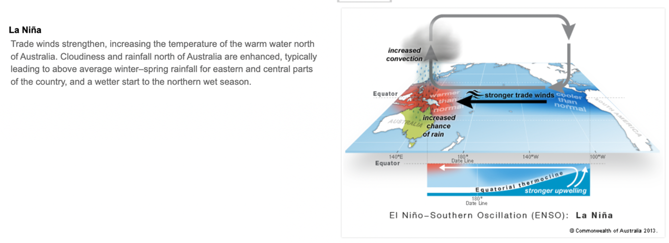
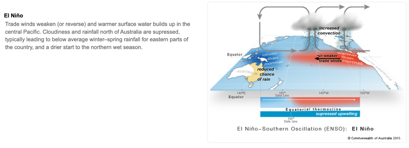
Let’s start with El Niño-Southern Oscillation (ENSO), which is the oscillation between El Niño and La Niña conditions. ENSO is an important teleconnection as it can change the global atmospheric circulation, which then influences temperature and precipitation around the Earth. Changes in ocean temperatures across the central and eastern tropical Pacific Ocean impact the atmospheric circulation and highlight the close interaction that exists between the ocean and the atmosphere. Many teleconnections influence Australia’s weather, but according to the Australian Bureau of Meteorology, El Niño and La Niña have perhaps the strongest influence on the year-to-year climate variability in Australia.
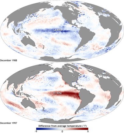
During La Niña events there is a cooling of the ocean surface or below average sea surface temperatures in the central and eastern tropical Pacific Ocean. This strengthens the easterly trade winds along the equator and there is a warming of the already warm sea surface temperatures to the north of Australia. This enhances rainfall north of Australia and typically increases the chance of above average rainfall for eastern, central and northern parts of Australia.
During El Niño the opposite is true. Sea surface temperatures in the central and eastern tropical Pacific Ocean become substantially warmer than average and this causes the prevailing equatorial trade winds which typically blow from east to west over the Pacific Ocean to weaken or even reverse. This results in the central and eastern Pacific area becoming more favourable for tropical rainfall and cloud development, which means that the heavy rainfall that usually occurs to the north of Australia moves to the central and eastern Pacific basin. In turn rainfall is usually reduced through winter-spring in Australia, especially across eastern and northern areas.
In August 2022, the Australian Bureau of Meteorology announced a third La Niña, which meant that the multi-year La Niña conditions that developed in the tropical Pacific in September 2020 had persisted. It was forecast that they would continue for at the least the rest of 2022, leading to this century’s first ‘triple-dip’ La Niña, which means the third La Niña in a row.
A #LaNiña event is underway, says @BOM_au
— World Meteorological Organization (@WMO) September 15, 2022
It's the first “triple-dip“ La Niña (3 northern hemisphere winters/southern hemisphere summers) since 1950 and the first of this century.
It will influence temperature and rainfall patterns till end of year.https://t.co/lcrUUnknEc pic.twitter.com/gdKzcPIpxI
ENSO doesn’t just influence the temperature and precipitation in Australia, the El Niño and La Niña cycle has an impact all over the Earth. For example, El Niño can limit the development of tropical cyclones in the Atlantic, whilst La Niña can enhance development. La Niña can also lead to drier conditions in East Africa. Research by the UK Met Office has also helped to show that El Niño years are a factor that can increase the colder winters in the UK. The impact of La Niña on the UK’s weather is less certain, but there are indications that historically it promotes high pressure to develop in the Atlantic during the late autumn and early winter. This tends to stop the milder prevailing south-westerly winds and can lead to cold weather. There are also indications that later in the winter, La Niña can drive the jet stream to the north of the UK, which can lead to an increase in heavy rain and stormy conditions.
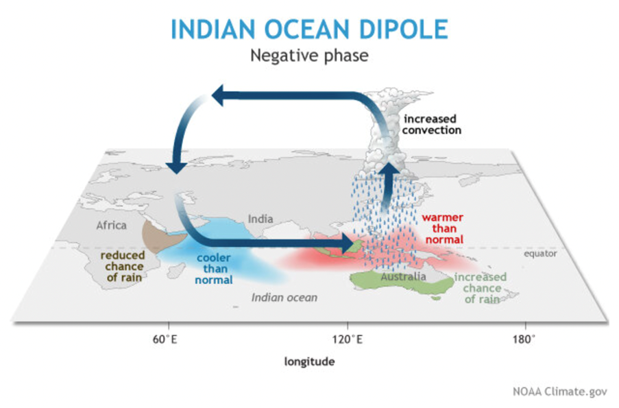
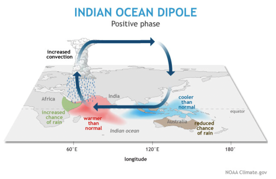
The Indian Ocean sea surface temperatures can also impact rainfall and temperature patterns over Australia. Warmer than average sea surface temperatures can provide more moisture for frontal systems and low pressure systems moving across Australia. The Indian Ocean Dipole (IOD) is the difference in sea surface temperature between the western and eastern Indian Ocean and is a key driver of Australia’s climate and can have a significant impact on agriculture as it generally coincides with the winter crop growing season. There are three phases of the IOD, neutral, positive and negative.
During the negative phase of the IOD westerly winds intensify along the equator allowing warmer waters to concentrate near Australia. This sets up a temperature difference across the tropical Indian Ocean with warmer than normal sea surface temperatures in the eastern Indian Ocean (west of Indonesia) and cooler than normal sea surface temperatures in the western Indian Ocean. This often means southern Australia is wetter than normal, whilst eastern Africa tends to be drier than normal.
During the positive phase of the IOD the westerly winds along the equator weaken allowing warm water to move towards Africa and cool water to rise up from the deep ocean in the eastern Indian Ocean. This results in warmer than normal sea surface temperatures in the western Indian Ocean and cooler than normal sea surface temperatures in the eastern Indian Ocean. This often results in less rainfall over central and south-eastern parts of Australia, whilst eastern Africa tends to be wetter than normal.
In instances when La Niña and a negative phase of the Indian Ocean Dipole (IOD) coincide (which is what is happening in Australia at the moment), the likelihood of above average rainfall over Australia, especially in eastern areas, is further increased. If both La Niña and the negative IOD are strong, then Australia can experience significant and widespread rainfall. This is the case for two of Australia’s three wettest years on record, 1974 and 2010.
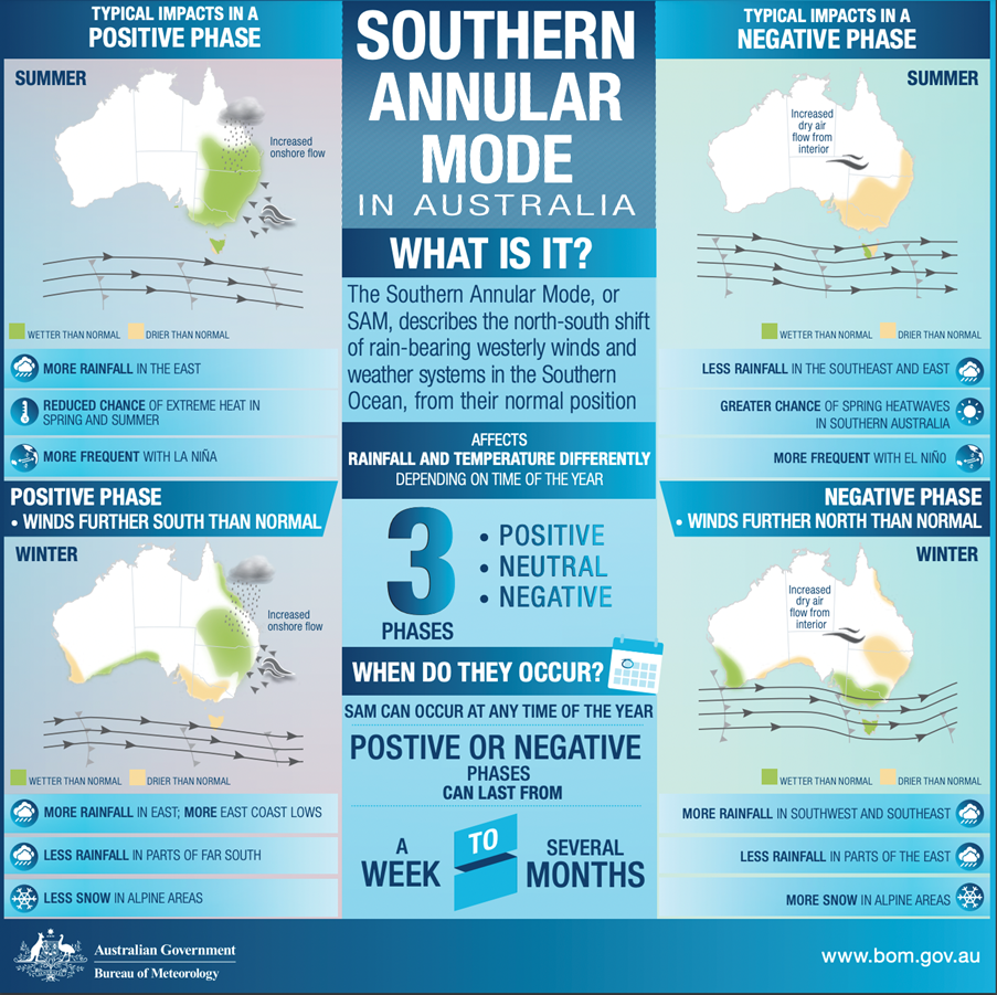
The Southern Annular Mode (SAM) can also influence rainfall in southern Australia. The SAM refers to the north/south movement of rain-bearing westerly winds and weather systems in the Southern Ocean compared to the usual position. The SAM has three phases – positive, negative and neutral, and each positive or negative phase usually lasts for one to two weeks, although longer periods may also occur. The effects that SAM has on rainfall varies greatly depending on the season as well as the region of Australia.
During the spring and summer months, a positive SAM increases the chance of above-average rainfall for parts of eastern New South Wales, eastern Victoria and south-eastern Queensland, and increases the chance of below-average rainfall for western Tasmania. In some seasons ENSO events (La Niña or El Niño) tend to favour a particular phase of SAM. La Niña tends to favour a positive SAM during the spring to summer months, typically enhancing the wet signals of La Niña.
According to the Australian Bureau of Meteorology, the SAM is showing an increasing tendency to remain in a positive phase during the summer and autumn months (December through to May), with westerly winds contracted towards the south pole. When the SAM is positive in summer, there tends to be more rainfall in eastern Australia. The contribution that the SAM makes to the climate variability in Australia and the apparent positive trend in the SAM are relatively recent discoveries and are still active areas of research. A strong polar vortex over Antarctica is also helping to promote a positive SAM. The polar vortex is a circulation of winds in the stratosphere (up to 30 miles above the Earth’s surface), and it is strongest during the colder months of the year.
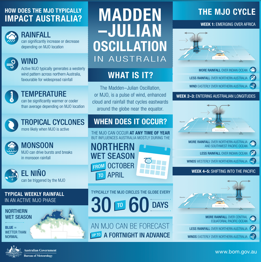
The Madden Julian Oscillation (MJO) is the major fluctuation in tropical weather on weekly to monthly timescales. It can be characterised as an eastwards moving ‘pulse’ of cloud and rainfall near the equator that typically recurs every 30 to 60 days. The effects of the MJO are most evident in the Indian Ocean and western equatorial Pacific, and it influences the timing, development and strength of major global monsoon patterns, such as the Indian and Australian monsoons. It is also associated with weekly to monthly periods of enhanced and suppressed rainfall over parts of Australia.
The latest forecast from the Australian Bureau of Meteorology (as of 6th December 2022) is for La Niña conditions to continue in the tropical Pacific into summer in the southern hemisphere, which typically increases the chance of above average rainfall for northern and eastern Australia. The latest indications from the models are for a return to ENSO-neutral values into January or February 2023. The Southern Annular Mode (SAM) is likely to be neutral to positive through December, boosted by La Niña and a strong polar vortex over Antarctica. A positive SAM in the summer months increases the chances of above average rainfall for parts of eastern New South Wales, eastern Victoria, southeastern Queensland and northeast Tasmania.
The sea surface temperatures around Australia have remained much warmer than average, and according to the Bureau of Meteorology the waters around Australia, in the northern tropics and in the Coral Sea set new October records. They also state that the waters across the Coral Sea were the warmest on record for November and spring. Warmer waters around Australia, especially in the tropics, can result in greater evaporation, humidity and rainfall.
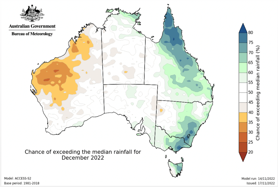
Looking ahead, the forecast for the three-month period (December 2022 to February 2023) is for the chance of above average rainfall for parts of south-east Australia, so the wet conditions may continue for some into the start of 2023.
About the Author

Gemma Plumb has been a meteorologist for 15 years and is currently working for DTN as a media meteorologist at the BBC. She has also forecast for a variety of sectors including energy, media, transport and utilities.
Gemma is one of the creators and hosts of the weather podcast - For the Love of Weather - which looks at the science behind weather and climate and how weather can impact our daily lives.
A keen science communicator, she is passionate about sharing her love of the weather. You can find Gemma on TikTok making funny, engaging and educational weather-related videos (@theweatherpud).
 © Ed Hawkins, University of Reading")


