
Snowmakers in the UK - part 1
Snow in the UK is a (fairly) rare and wonderous thing. No other weather phenomena can provoke the level of media interest/hyperbolae. Transport systems into, out of and between major urban centres are seriously disrupted by even a light fall. A significant snowfall puts a particularly large spanner in the works! We cannot have systems like those in Scandinavia and the US to cope with these conditions as they are rarely severe enough, for long enough, to make such provision cost effective. One might say, we are caught between a rock and a snowy place.
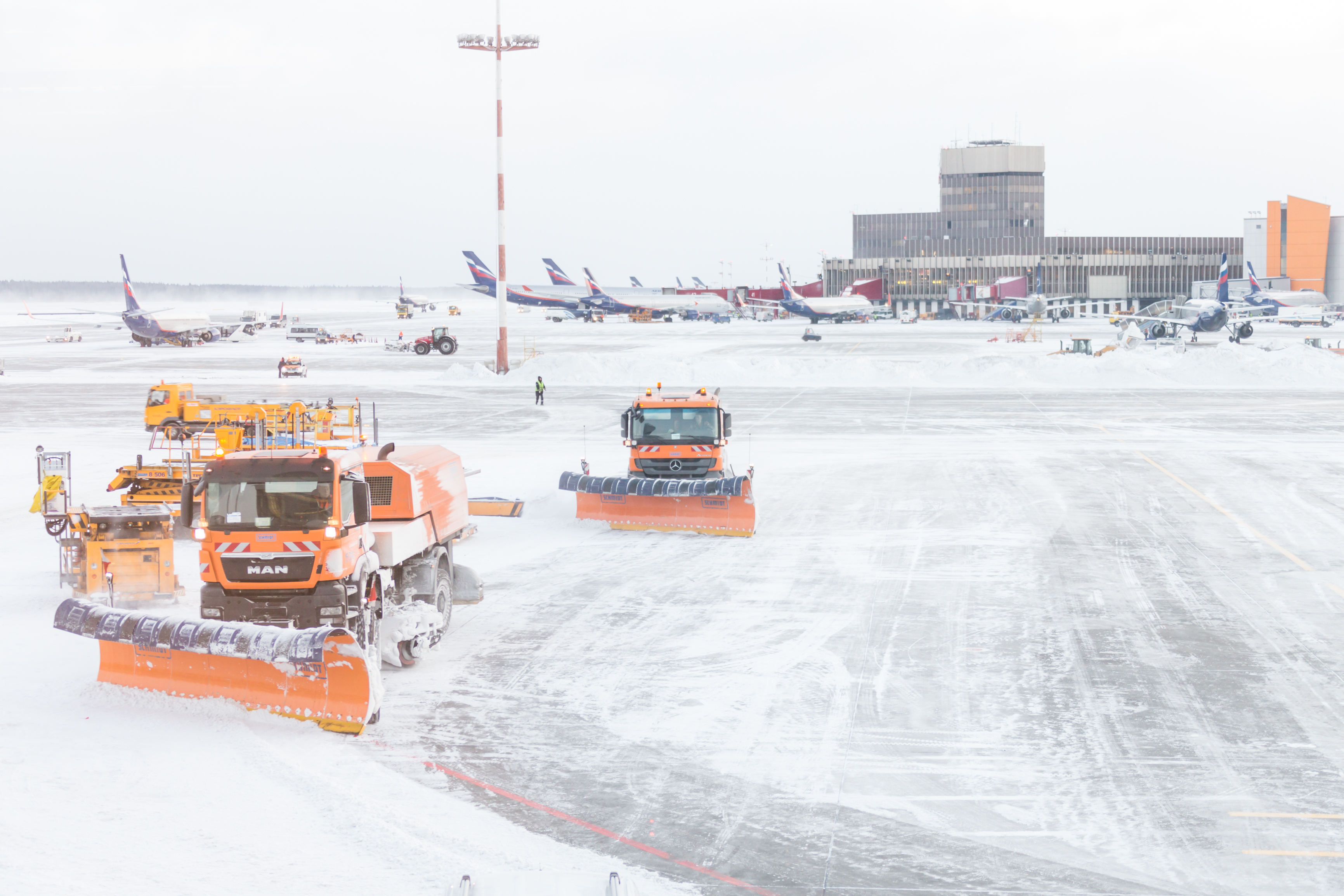
Forecasting snowfall is therefore very important; it is obvious when things go wrong. Forecasting reputations can be won and lost on a snow forecast.
As with forecasting most weather phenomena, the devil is in the detail. This is particularly so with snow. Only a small change in conditions can turn rain into sleet or snow and back again. Weather presenters sometimes use the phrase ‘wintry precipitation’. This is code for ‘something is going to fall but we are not sure exactly what!’. Small forecast errors that can produce a large change in impact is a forecasting nightmare!
Detailed snow forecasting takes training, experience and, even now, a little bit of luck. However, on a larger scale, it is possible to identify weather scenarios that turn your thinking from the usual, ‘Why will it snow?’ to ‘Why won’t it snow?’ In these articles I am going to look at two such scenarios. Today, the warm occlusion.
Warm occlusions can give rise to the heaviest and most disruptive snowfalls. An occlusion is a type of weather front, a boundary between air masses. It is associated with the later stages in the life cycle of a depression or low-pressure system. Cold occlusions are common throughout the year and are very similar to cold fronts. In fact, at the surface, it is difficult to tell them apart without context. Warm occlusions, however, are rare in the UK and can only occur in winter. They are similar to warm fronts, but the temperature contrast across the front is very large.
So, what makes the difference? It all hinges on the air ‘ahead’ of and ‘behind’ the weather system.
In a ‘normal’ cold occlusion, the air ‘behind’ the system is colder than the air ‘ahead’.
In a warm occlusion, the air ‘ahead’ of the system is colder than that ‘behind’ (the diagrams below will help you visualise this).
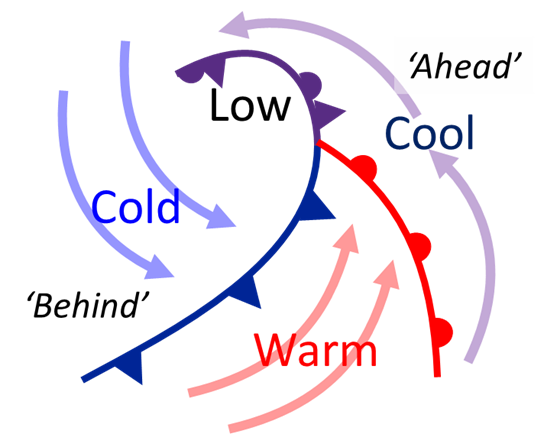
On an analysis chart, the cold occlusion extends the curve of the cold front.
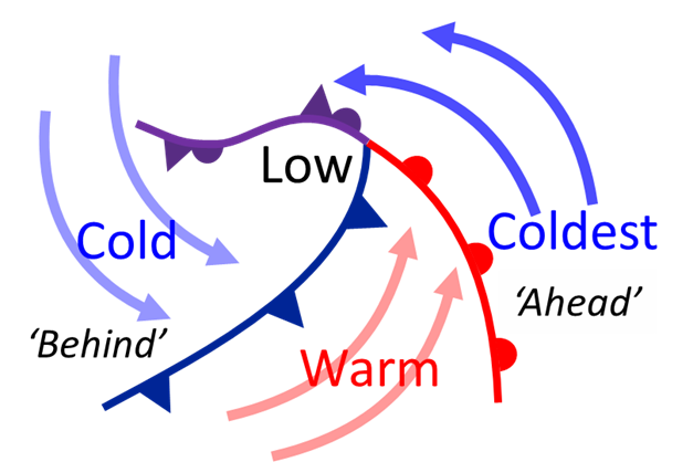
On an analysis chart, the warm occlusion extends the curve of the warm front
In order to have the coldest air ahead of the system, that air must be drawn from a very cold source. During the summer months, air from the east is very warm. But in winter, the air from the east is very cold and is known as a Polar continental air mass. Headline writers love this set up, and often refer to the cold, dry easterly as the ‘Beast from the East’ or ‘A Siberian blast’.
The Polar continental air mass itself is very dry so little precipitation falls from it directly. The moisture comes with the warm air mass that follows. The warm, moist air is forced to rise over the very cold dense continental air. As the air rises it cools, thick cloud develops, and precipitation starts to form.
At our latitudes, it is difficult to ‘grow’ water droplets large enough, fast enough, for them to fall as rain. This means that over the UK, almost all precipitation starts off as snow or hail. Normally these melt as they fall, although hail falls very quickly so can reach the ground at any time of year. Snow, on the other hand, falls slowly and has more time to melt before reaching the ground. But with a warm occlusion, the very cold air underneath prevents the snow from melting and allows it to reach the ground. As a side note, forget what you’ve heard about rain ‘turning’ to snow. What you see at ground level is snow that hasn’t melted!
That covers why it snows but what about where? This is down to the track of the centre of the low-pressure system.
A low centre that passes to the north of your location may produce snow in the cold air ahead of the warm front, but eventually the warm air moves in and clears it, so the snow is only a temporary disruption. However, if the low centre takes a more southerly track, the warm air won’t reach your location. The snow does not melt and that can lead to serious disruption, as I can testify!
In January 1982 an area of low pressure ran along the English Channel. The associated warm occlusion produced heavy snowfall for 36 hours over south Wales and much of southern England. There was also a very strong easterly wind. Temperatures were low, -2 ºC to -4 ºC. The snow was powdery and large drifts formed. I was there at the time. It was my first winter as an observer at Cardiff Wales Airport. I was stuck there for a week. When I eventually got out, I was amazed that even a week after the snowfall most roads were still single track, and looked rather like bobsleigh runs with snow piled up on both sides as high as a double decker bus in places!
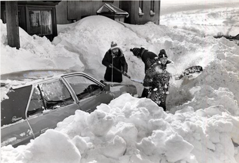
Snowdrifts in Bedlinog (Beddllwynog) 8th January 1982
Now January 1982 was a ‘Goldilocks’ combination of wind, snow and temperature that is unlikely to be repeated. However, if you are on snow watch, my advice is to look out for low pressure centres that go to the south of your location. In that situation it is worth paying close attention to the forecast just in case.
In part 2, Frank will take a closer look at our second snow bringer - Polar lows.
About the author
Frank Barrow retired from the Met Office in 2020, after a career of 39 years during which he worked as an observer in the 1980s, a forecaster in the 90s and, since 1996, as a trainer at the Met Office College. He describes the latter role as “fitting him like a glove”, so he stayed... for almost 25 years! During that time, he was involved in the training of the vast majority of current Met Office forecasters.

 © Ed Hawkins, University of Reading")

