
Stunning images from the newest European weather satellite
Take a closer look at this stunning satellite image. It is the first image from the new generation of European weather satellites, released in May 2023 by Europe’s meteorological satellite agency (EUMETSAT) and the European Space Agency (ESA).
Most importantly for the UK and Nordic countries, this image reveals a greater level of detail at high latitudes, something that wasn’t possible from a geostationary orbit until now.
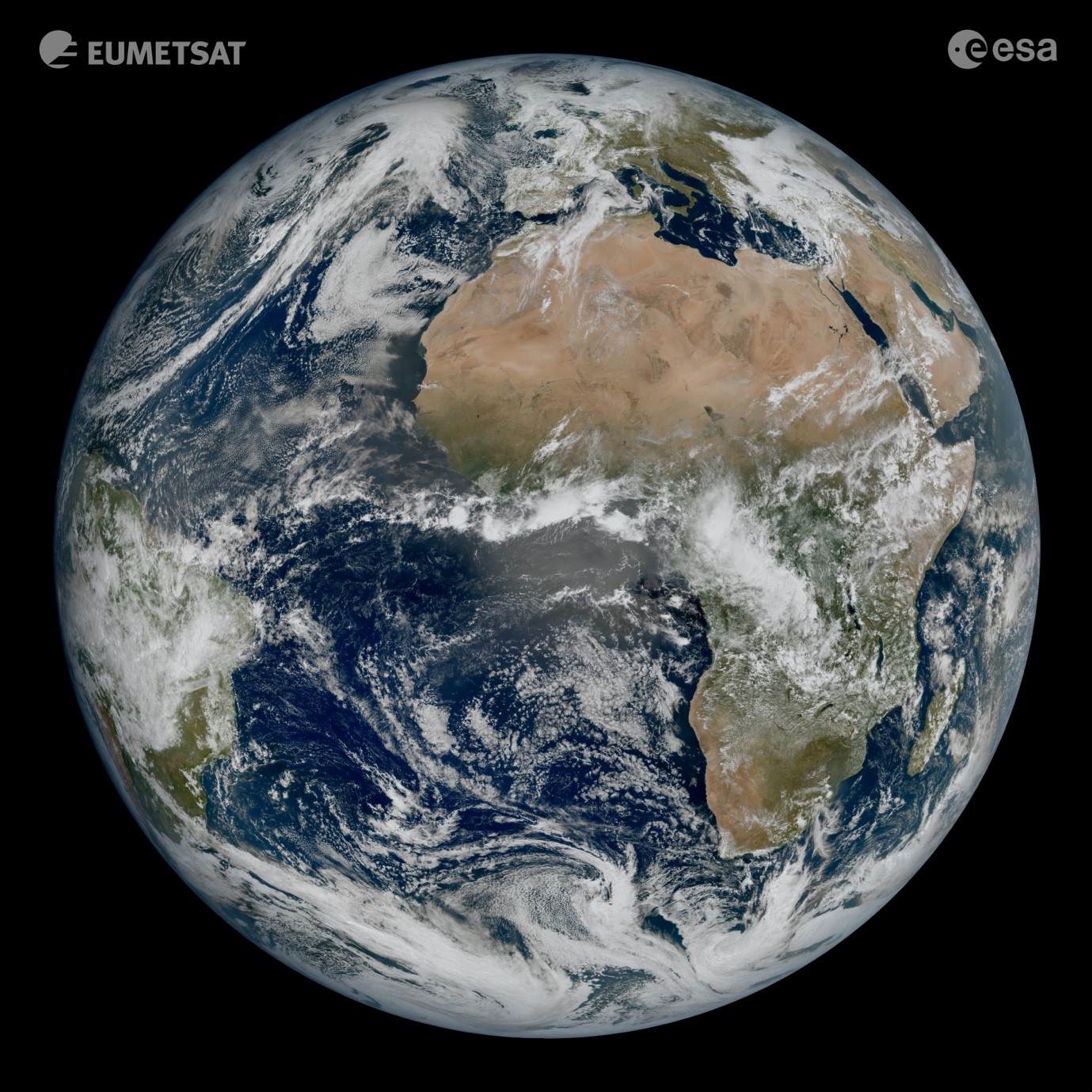
This is the first image from EUMETSAT’s new Meteosat Third Generation – Imager 1 (MTG-I1) satellite that was captured at 11:50 UTC on 18 March 2023
There are so many amazing details you can see in the image, from "cloud streets" over the Greek Islands to “von Kármán vortices” downstream of the Canary Islands – both these cloud features are created by the wind. You can also see the sand and sediment in the waters off Italy and the snow on the Alps. These features are clearly visible in the ‘zoomed in’ image of Europe below.
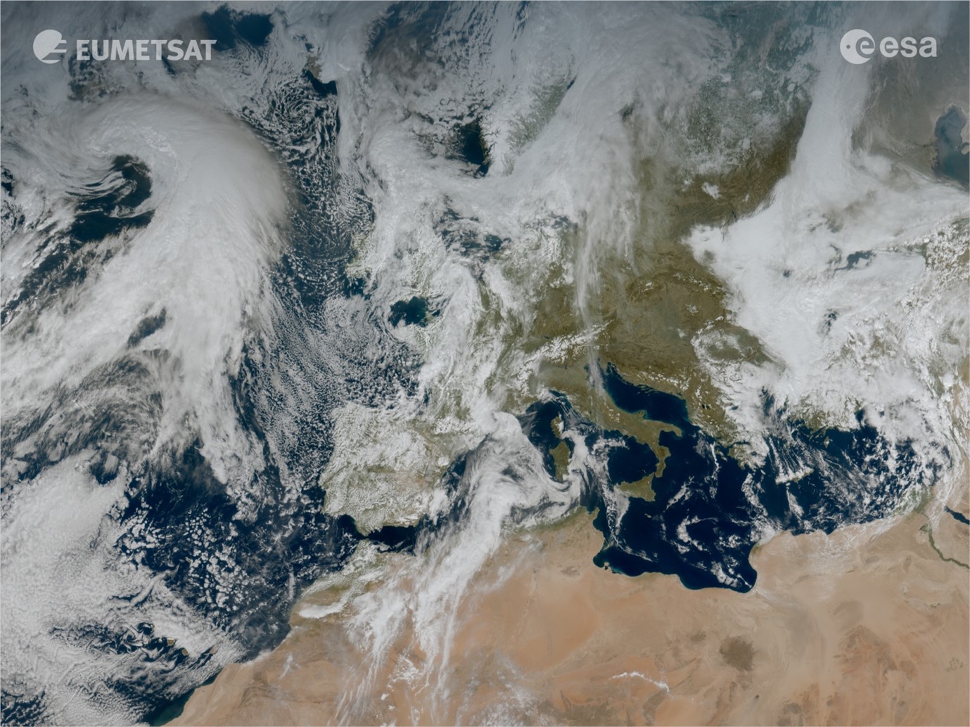
This is a ‘zoomed in’ view of Europe taken from MTG-I1’s first image. It shows amazing cloud features such as cloud streets over the Greek Islands and von Kármán vortices downstream of the Canary Islands – both cloud features are created by the wind
The level of detail of the cloud structures that you can see in the image is amazing, and very important to weather forecasters. MTG-I1 offers a higher resolution of imagery and will produce images more frequently (every 10 minutes), which means that forecasters will be able to detect and predict severe weather events more rapidly and accurately. It also means that forecasters will be able to track the development of storms in near-real time, meaning severe weather warnings can be issued more quickly, saving time and lives.
The image above was taken by the Meteosat Second Generation (Meteosat-11) satellite at 11:45 UTC on 18 March 2023.
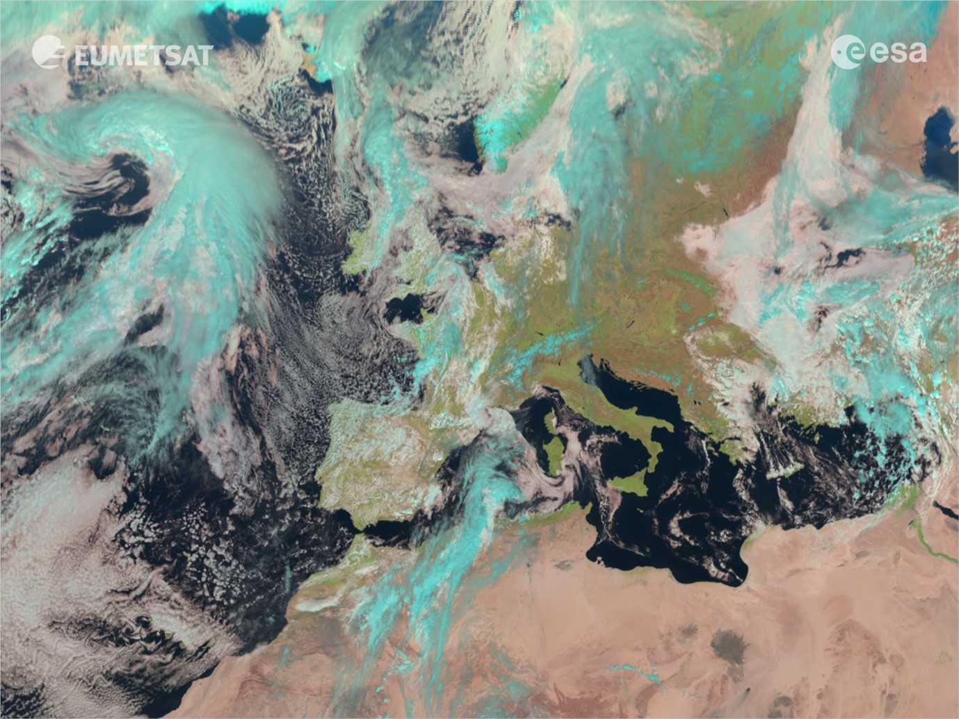
The image below was taken by the new MTG-I1 satellite (Meteosat-12) at 11:50 UTC on 18 March 2023.
You can see from the images that the one taken by the new MTG-I1 satellite offers so much more detail, with better true colour imagery that will be useful for detecting dust, haze, smoke, cloud properties and wildfires.

The satellite was launched on 13 December 2022 from the Guiana Space Center in Kourou, French Guiana. The first image from the satellite was captured at 11:50 UTC on 18 March 2023 and revealed on Thursday 4 May 2023.
This stunning first image was taken at 11:50 UTC on 18 March and shows cloudy conditions over Europe, Africa & the Atlantic 🤩
— EUMETSAT (@eumetsat) May 4, 2023
This level of detail wasn't possible over Europe & Africa from a geostationary orbit before!
For more info & imagery visit: https://t.co/FIHkypY1T9 pic.twitter.com/hdCuAqIsc5
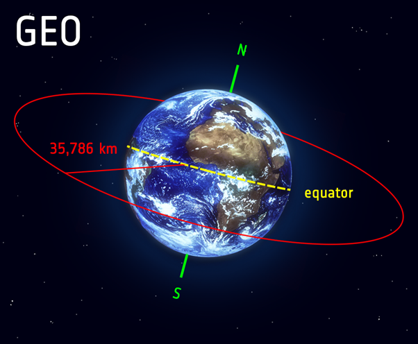
MTG-I1 will be positioned 36,000km above the Earth's equator, and will provide a constant view over Europe and Africa. It is a geostationary satellite, which means it travels at speeds equal to the Earth’s rotation and this allows it to maintain its position over a specific geographic region and can provide continuous coverage of this area over time. According to the European Space Agency – ‘Satellites in geostationary orbit circle the Earth above the equator from west to east following the Earth’s rotation – taking 23 hours, 56 minutes and 4 seconds – by travelling at exactly the same rate as Earth. This makes satellites in geostationary orbit appear to be ‘stationary’ over a fixed position’.
The satellite, its instruments and the ground-based infrastructure that is required to process the images will continue to undergo testing, calibration and validation until the end of 2023. After this time the images will be produced every 10 minutes and will be released operationally for use in weather forecasts, which is very exciting.
MTG-I1 is the first geostationary weather satellite with the capability to detect lightning across a broad area of Europe, Africa and the surrounding waters. The lightning imager onboard the satellite will provide near real-time data on the location and intensity of lightning flashes in its field of view. The lightning imager will continuously monitor more than 80% of the Earth disc for lightning flashes that occur either between clouds or between clouds and the ground. According to EUMETSAT, “this data will provide a major boost to very short-term nowcasting and numerical weather prediction models, which support longer-term forecasts”.
MTG-I1 is the first of six satellites that form the full Meteosat Third Generation series (MTG), which will provide critical data for weather forecasting over the next 20 years. The MTG mission is a cooperation between EUMETSAT and the European Space Agency (ESA). ESA is responsible for developing and procuring the six MTG satellites; and EUMETSAT defines the system requirements, develops the ground systems, procures the launch services, operates the satellites and makes the data available to users.
The next satellite to be launched in the MTG series is MTG-S1, which is dedicated to atmospheric sounding. This satellite will feature an instrument that can provide information on atmospheric temperature, humidity and dynamics at high temporal resolution. This satellite is currently expected to be launched in 2024.
Meteosat satellites have been providing observations from space over Europe, Africa and the surrounding waters since the late 1970s, and they provide a critical part of the satellite observations used for weather forecasting.
MetMatters can’t wait until the MTG-I1 satellite is fully operational at the end of 2023 and we get to enjoy more of these stunning images.
© EUMETSAT/ESA
This animation was made using one day’s worth of data from MTG-I1, from 11:50 UTC 18 March to 11:50 UTC 19 March 2023. Images of the full Earth disc are produced by MTG-I1 every 10 minutes.
About the Author

Gemma Plumb has been a meteorologist for 15 years and is currently working for DTN as a media meteorologist at the BBC. She has also forecast for a variety of sectors including energy, media, transport and utilities.
Gemma is one of the creators and hosts of the weather podcast - For the Love of Weather - which looks at the science behind weather and climate and how weather can impact our daily lives.
A keen science communicator, she is passionate about sharing her love of the weather. You can find Gemma on TikTok making funny, engaging and educational weather-related videos (@theweatherpud).
 © Ed Hawkins, University of Reading")


