
Weather Photographer of the Year 2022: Behind last year's winning images - mist and fog
The difference between mist and fog
Mist and fog are common phenomena in the UK, and are both formed in the same way. The difference is set by an essentially arbitrary measure of the visibility within the mist or fog. If visibility is less than 10km it can be called mist, if less than 1km it is called fog. These figures were chosen with safety at sea and in the air in mind. Nowadays, the importance of road transport means different limits are used in public service forecasts. The definition of mist remains the same, but fog requires visibility to be 200m or less.
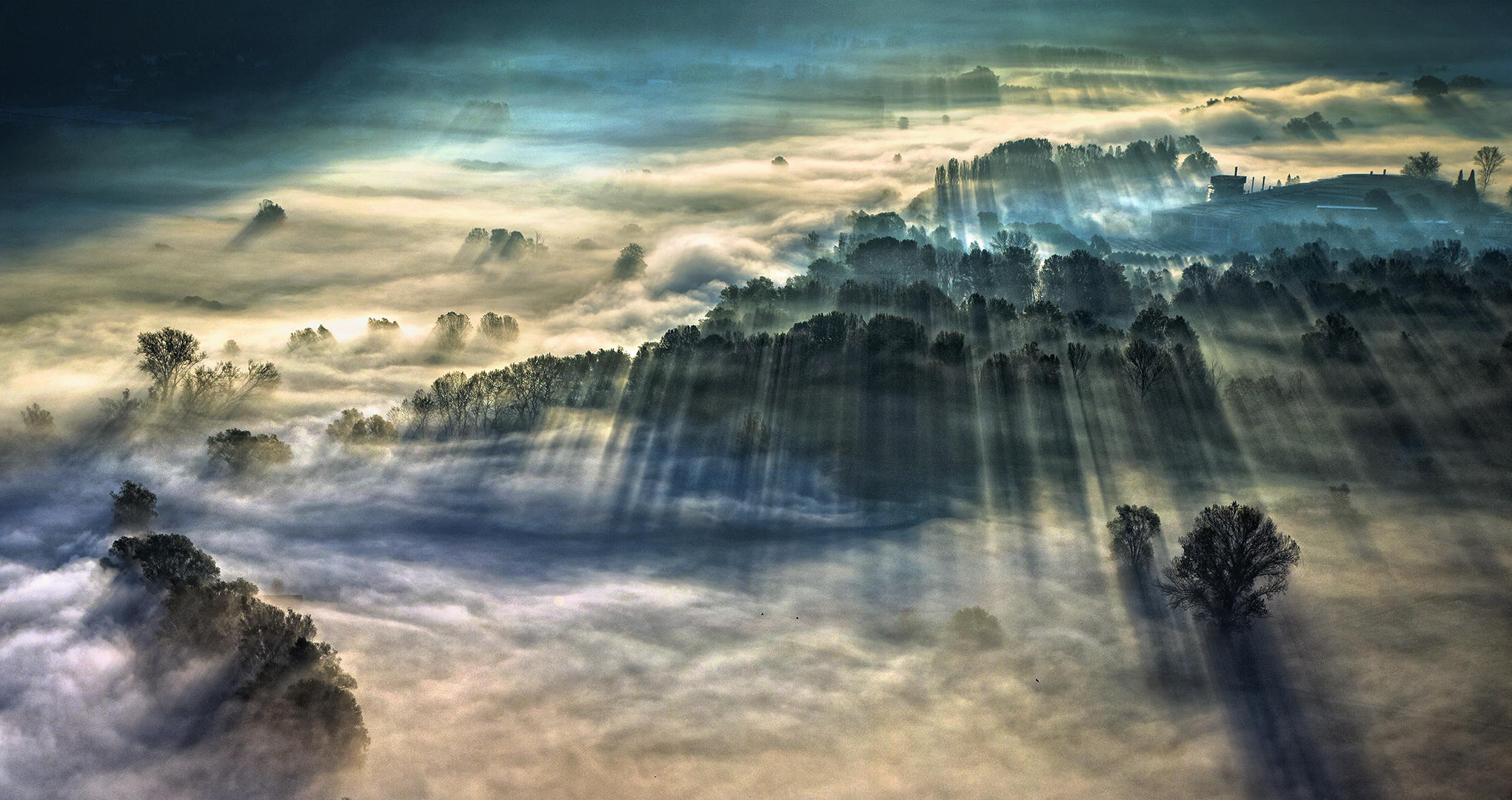
Giulio Montini’s spectacular photo, ‘Morning Fog’, taken from a hilltop in the Italian town of Airuno, took the title of Weather Photographer of the Year 2021. As the sun rose, the mist and fog hanging over the river briefly created this surreal landscape. Giulio says the hours spent in the autumn cold waiting for the perfect light and conditions were worth it. Through the fog and with the help of the trees, you can just about see the winding course of the river Adda, illuminated by the first lights of sunrise.
How do they form?
Mist and fog form due to condensation onto microscopic particles known as condensation nuclei. Condensation nuclei are all around us. We breathe them in and out without noticing, but without them, it is difficult if not impossible for condensation to occur. Two things are needed for mist or fog to form: moisture, and some way of cooling the air until condensation occurs.
Sources of moisture are available in many locations. The limiting factor is usually cooling. The easiest way of cooling air in the atmosphere is to make it rise. Rising air forms cloud. However, except for air forced to rise over hills, this will not necessarily reduce surface visibility. Fog and mist are produced by cooling of the ground that spreads to no more than a few hundred feet above ground level. Surface cooling is due to the escape of longwave radiation to space.
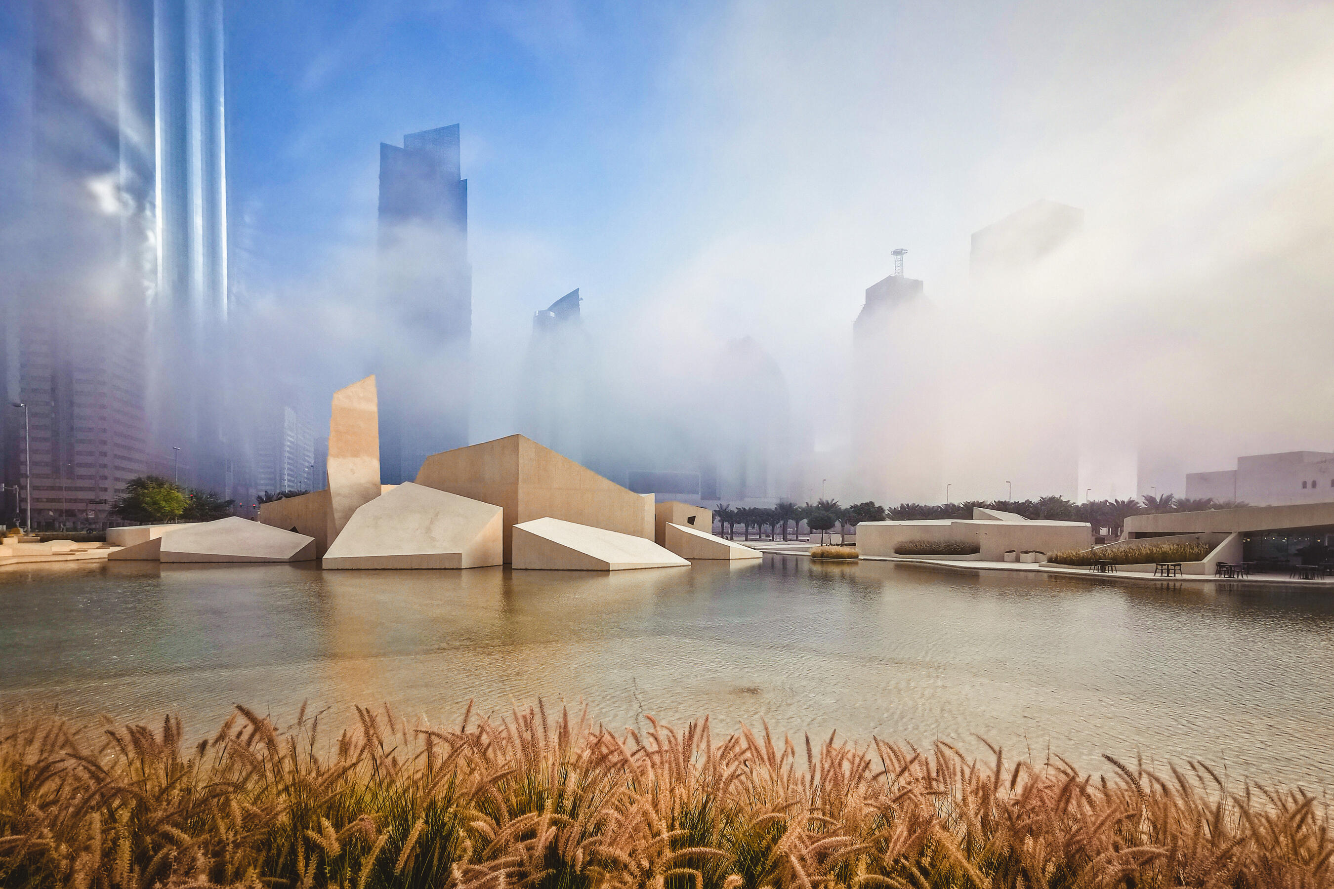
Fog was also the subject of the 2021 winning photograph in the new Mobile Phone category. Christopher de Castro Comeso took his photo ‘Foggy Morning’ of the Qasr Al Hosn in Abu Dhabi. Around 95 per cent of the fog observed in the UAE is radiation fog, which is most common in winter.
Optimum conditions for the formation of ‘radiation’ fog:
- Clear sky or just thin high cloud - Allows radiation to escape to space
- Moist ground - Sources of moisture
- Moist air in the lowest 100m or so - Sources of moisture
- Light surface winds - A small amount of turbulence is useful
- Favourable local topography - Cold air draining into hollows and valleys concentrates the surface cooling
Given that fog and mist are quite common phenomena, the process of fog formation is surprisingly complex. It requires a sequence of events.
Firstly, the cooling at the surface lowers the temperature of the air in contact with it. Dew is deposited. Turbulence forms a slight breeze that sustains the dew deposition. Surface temperature and dew point fall. Next, there is a temporary lull in the light surface wind. This results in condensation occurring in the air near the surface. Shallow fog forms. Visibility is still above all fog limits as the fog is below eye level.
As radiative cooling from the surface continues, the fog deepens, and visibility drops to below fog limits for air and sea transport (<1000m). Most people would probably still describe this as mist. Eventually, the fog is deep enough to absorb all the radiation from the ground. Cooling now occurs at the top of the fog, trapping it and causing visibility to decrease to below road fog limits (<200m).
Have you taken a misty masterpiece or a phenomenal photo of fog?
If you have taken a great weather picture, we'd love to see it. Enter the Royal Meteorological Society's 'Weather Photographer of the Year' competition - it's free and open to photographers, professional and amateur, of all ages and abilities.
'Weather Photographer of the Year', in association with AccuWeather, attracted almost 9,000 photos last year, seen by millions of people across the world, and there are some great prizes on offer as well as bragging rights of course!
This year's line-up of judges includes experienced meteorologists, photographers and photo editors. They will look for images that combine photographic skill with meteorological observation and storytelling. To discover the audience favourite, shortlisted entries in the main and mobile competitions will also be put to a public vote in August and September.
What are you waiting for? Get snapping!

 © Ed Hawkins, University of Reading")

